IMAGES TAKEN NEAR TO
Wheatsheaf Road, HENFIELD, BN5 9AP
Introduction
This page details the photographs taken nearby to Wheatsheaf Road, BN5 9AP by members of the Geograph project.
The Geograph project started in 2005 with the aim of publishing, organising and preserving representative images for every square kilometre of Great Britain, Ireland and the Isle of Man.

There are currently over 7.5m images from over14,400 individuals and you can help contribute to the project by visiting https://www.geograph.org.uk
Image Map
Images are licensed for reuse under creativecommons.org/licenses/by-sa/2.0
Notes
- Clicking on the map will re-center to the selected point.
- The higher the marker number, the further away the image location is from the centre of the postcode.
Image Listing (11 Images Found)
Images are licensed for reuse under creativecommons.org/licenses/by-sa/2.0
Image
Details
Distance
1
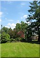
Garden Cottages, Chestham Park
Possibly dating back to the 16th century and the only surviving dwellings of a small hamlet that once existed here prior to the building of Chestham Park in the mid 1820s.
Image: © Simon Carey
Taken: 18 Jun 2017
0.05 miles
3
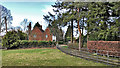
Drive leading to Chestham Park
The public footpath is on the left side of this fence. The landowner is very determined that walkers shouldn't stray onto the driveway (to the right of the fence). There are numerous warnings of prosecution, loose dogs, etc! I saw the dogs and they do indeed look quite fierce - dobermanns I think.
Image: © Ian Hawfinch
Taken: 17 Feb 2020
0.13 miles
4
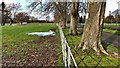
North Field/Barn Field
The name of the fields according to Henfield's 1844 tithe map that have been merged to form a larger unit. Both are located to the north of the complex of buildings surrounding Chestham Park house and south of Image with North Field located on the western side with Image to the south west and Image to the north west. Barn Field is located on the eastern side.
Image: © Simon Carey
Taken: 18 Jun 2017
0.13 miles
5
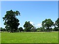
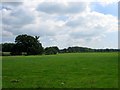
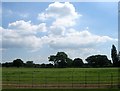
Chestham Park (3)
Looking westwards from near the main house. the park was laid out in the 1820s and consists of around 46 acres located to the north and east of the A281 and B2116. Some of the trees in the landscape would once have been part of the hedgerows of the former field that once existed here.
Image: © Simon Carey
Taken: 18 Jun 2017
0.14 miles
6
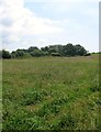
Hither Rye Croft
The name of the field according to Henfield's 1844 tithe map that is bounded by Image to the south and Image to the west.
Image: © Simon Carey
Taken: 18 Jun 2017
0.14 miles
7
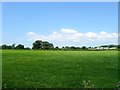
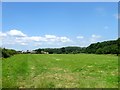
Kennel Field
The name of the field according to Henfield's 1844 tithe map that is bounded by Chestham Park to the south, Image to the north and Image to the east. Nymans Farm can be seen in the distance.
Image: © Simon Carey
Taken: 18 Jun 2017
0.15 miles
8
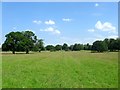
Chestham Park (1)
Laid out in the 1820s and consisting of roughly 46 acres located to the north and east of the A281 and B2116. The oaks on the left appear to have once been part of a hedgerow and have been incorporated into the parkland layout.
Image: © Simon Carey
Taken: 18 Jun 2017
0.21 miles
9
Chestham Park (2)
This is the eastern end of the park betond the drive to the main house. The park was laid out in the 1820s and consists of around 46 acres located to the north and east of the A281 and B2116.
Image: © Simon Carey
Taken: 18 Jun 2017
0.21 miles
10
Middle Rye Croft
The name of the field according to Henfield's 1844 tithe map that is bounded by Image to the south, Image to the east and Image to the west. The outbuildings in the distance are part of Nymans Farm whilst to the right is Marl Wood.
Image: © Simon Carey
Taken: 18 Jun 2017
0.22 miles