IMAGES TAKEN NEAR TO
Clayton Hill, BRIGHTON, BN45 7FF
Introduction
This page details the photographs taken nearby to Clayton Hill, BN45 7FF by members of the Geograph project.
The Geograph project started in 2005 with the aim of publishing, organising and preserving representative images for every square kilometre of Great Britain, Ireland and the Isle of Man.

There are currently over 7.5m images from over14,400 individuals and you can help contribute to the project by visiting https://www.geograph.org.uk
Image Map
Images are licensed for reuse under creativecommons.org/licenses/by-sa/2.0
Notes
- Clicking on the map will re-center to the selected point.
- The higher the marker number, the further away the image location is from the centre of the postcode.
Image Listing (38 Images Found)
Images are licensed for reuse under creativecommons.org/licenses/by-sa/2.0
Image
Details
Distance
1
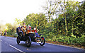
1903 De Dion Bouton on the A 273
De Dion Bouton, detachable top brougham, on the last part of the hill before the course joins the A23.
Image: © Christine Matthews
Taken: 2 Nov 2008
0.01 miles
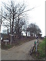
2
Permissive Bridleway to Rockrose
Giving a link to those who wish to leave the South Downs Way here to head on up to Wolstonbury Hill. The bridleway runs parallel with the A273 up to the public bridleway near the riding school.
Image: © Simon Carey
Taken: 20 Dec 2009
0.07 miles
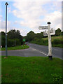
3
The South Downs Way National Trail crosses the A273 at Pyecombe Golf Club
Image: © Shazz
Taken: 27 May 2011
0.07 miles
4
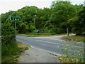
South Downs Way crossing the A273 near Pyecombe
The South Downs Way crosses the A273 road at this point, close to the village of Pyecombe.
Image: © Malc McDonald
Taken: 8 Jan 2017
0.08 miles
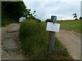
5
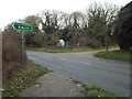
A273 Clayton Hill, near Pyecombe
The A273 road, at the point where it is crossed by the South Downs Way.
The signpost indicates that the South Downs Way can be used by people walking, cycling or on horseback.
Image: © Malc McDonald
Taken: 8 Jan 2017
0.08 miles
7
Golf warning on the South Downs Way National Trail
The notice warns of flying golf balls.
Image: © Shazz
Taken: 27 May 2011
0.09 miles
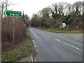
8
Clayton Hill
Looking up the A273 from the junction with School Lane. An early example of a bypass as it was constructed in the mid 19th century to avoid the steep climb into Pyecombe. This stretch of road can be quite dangerous as the southbound traffic has a tendency to speed down the hill whilst the northbound zooms off the A23 often ignoring the 50mph speed limit and the signs concerning the South Downs Way whose users, on foot and horseback, cross the road halfway up. In fact School Lane takes the South Downs Way into Pyecombe having followed the road down the hill and meeting the lane to the left of the green warning sign.
Image: © Simon Carey
Taken: 22 Aug 2008
0.10 miles
9
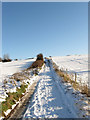
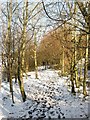
South Downs Way
The section between the A273 and the crossing of bridleways to the south of New Barn Farm passes between the greens of Pyecombe Golf Course which was established in 1894 on an area of downland called Waydown. The snow had fallen 48 hours previously.
Image: © Simon Carey
Taken: 20 Dec 2009
0.11 miles
10
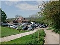
The clubhouse, Pycombe Golf Course
An attractive course alongside the South Downs Way
Image: © Tim Heaton
Taken: 13 May 2012
0.12 miles