IMAGES TAKEN NEAR TO
Pyecombe Street, BRIGHTON, BN45 7EE
Introduction
This page details the photographs taken nearby to Pyecombe Street, BN45 7EE by members of the Geograph project.
The Geograph project started in 2005 with the aim of publishing, organising and preserving representative images for every square kilometre of Great Britain, Ireland and the Isle of Man.

There are currently over 7.5m images from over14,400 individuals and you can help contribute to the project by visiting https://www.geograph.org.uk
Image Map
Images are licensed for reuse under creativecommons.org/licenses/by-sa/2.0
Notes
- Clicking on the map will re-center to the selected point.
- The higher the marker number, the further away the image location is from the centre of the postcode.
Image Listing (32 Images Found)
Images are licensed for reuse under creativecommons.org/licenses/by-sa/2.0
Image
Details
Distance
1
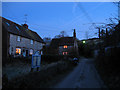
Pyecombe Street at Dawn
The name of the street and small settlement about half a mile north of Pyecombe which grew up from the 17th century when the original settlement around the church was virtually abandoned. Until the 19th century this was the most populous part of Pyecombe but the coming of the turnpikes heading for the rapidly expanding resort of Brighton shifted the settlement back to its original position. The street itself ends just beyond Woodbine Cottage and becomes a bridleway heading up to Wolstonbury Hill. A solitary street lamp and Christmas lights in a few windows are the only light half an hour before sunrise.
Image: © Simon Carey
Taken: 28 Dec 2009
0.01 miles
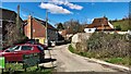
2
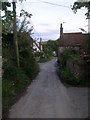
Woodbine Cottage, Pyecombe Street
This part of Pyecombe grew up in the 16th century when the population deserted the older medieval settlement around the church possibly due to an outbreak of plague. Consequently, the oldest buildings, bar the church, are found in this part. With the growing importance of London-Brighton communications in the late 18th century the older, deserted part found itself growing again until it became the more populated part of the village once more.
Image: © Simon Carey
Taken: 22 Aug 2008
0.01 miles
3
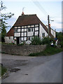
Pyecombe Manor
A remnant of a much bigger 16th century house, possibly a manor house though records indicate the manor resided in Pangdean rather than Pyecombe, so this may have been a large house built after the village moved its centre of population away from Pyecombe church to this part known as Pyecombe Street.
Image: © Simon Carey
Taken: 22 Aug 2008
0.02 miles
4
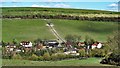
Houses and buildings in Pyecombe
This is looking back towards Pyecombe from the footpath on Cow Down.
Image: © Ian Hawfinch
Taken: 16 Mar 2020
0.03 miles
5
Pyecombe House
Viewed from the western side of the footbridge that spans the A23. The house was once the village general stores and post office but became a saddlery before being converted to residential use. The cars on the eastern side are parked along the old route of the A23.
Image: © Simon Carey
Taken: 22 Aug 2008
0.04 miles
7
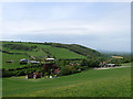
Pyecombe Street
There are two settlements within the parish of Pyecombe, the village itself and Pyecombe Street. The original medieval village was based around the church next to an ancient east-west route which travelled across the Downs. However, this decayed and sometime in the 15th or 16th century the residents upped sticks and moved a quarter of a mile up the road leaving the church isolated. Pyecombe Street remained the more populous part of the parish until the late 18th century when the growth of nearby Brighton as an aristocratic tourist destination led to a proliferation of turnpikes that linked London via various routes through Sussex to the coast. One of these came via Clayton Hill and past the doorstep of the church and as a result 'old' Pyecombe began growing again, until the mid 20th century when once again it became the more populous part of the parish.
On the far side of the gap is Cow Down with Newtimber Holt to the right and Wayfield Farm in the centre. The route of the A23(T) is marked by a line of bushes whilst on this side at the foot of the hill on the left is Frithmans with Plough Farm to the right.
Image: © Simon Carey
Taken: 10 May 2009
0.04 miles
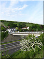
8
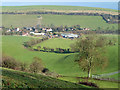
Pyecombe Street from Newtimber Hill
The dual carriageway A23 passes in a cutting between the nearer farm buildings and the further houses, which are reached from the right by the stub end of the old course of the A23 here.
Image: © Robin Webster
Taken: 16 Jan 2011
0.05 miles
9
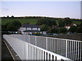
Footbridge Over the A23
Connecting the bridleways on the west side of the dual carriageway to Pyecombe Street.
Image: © Simon Carey
Taken: 10 May 2009
0.05 miles
10
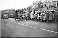
Old Crocks Run
A vehicle taking part in the annual London to Brighton veteran Car Run reaches the top of Dale Hill Pyecombe. At the time the A23 only had a single carriageway in each direction, and there was direct access to Pyecombe Village just to the right of the photo.
Image: © Peter Jeffery
Taken: Unknown
0.06 miles