IMAGES TAKEN NEAR TO
Rosemary Avenue, STEYNING, BN44 3YS
Introduction
This page details the photographs taken nearby to Rosemary Avenue, BN44 3YS by members of the Geograph project.
The Geograph project started in 2005 with the aim of publishing, organising and preserving representative images for every square kilometre of Great Britain, Ireland and the Isle of Man.

There are currently over 7.5m images from over14,400 individuals and you can help contribute to the project by visiting https://www.geograph.org.uk
Image Map
Images are licensed for reuse under creativecommons.org/licenses/by-sa/2.0
Notes
- Clicking on the map will re-center to the selected point.
- The higher the marker number, the further away the image location is from the centre of the postcode.
Image Listing (100 Images Found)
Images are licensed for reuse under creativecommons.org/licenses/by-sa/2.0
Image
Details
Distance
1
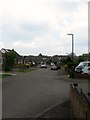
Rosemary Avenue, Steyning
A cul de sac off King's Barn Lane that was built in the 1960s.
Image: © Simon Carey
Taken: 15 May 2016
0.01 miles
2
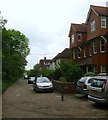
King's Barn Villas, Steyning
A cul de sac off King's Barn Lane that was developed from the late 19th century onwards. Located next to the former railway this piece of land began life as a timber yard which had closed by the time of the 1897 OS map. The northern end had become a wool store whilst the track slowly began to be developed with housing with those on the right, Lucastes and Haltwhistle erected in the first decade of the 20th century. The rest of the road was infilled during the 1950s and 60s. Just visible in the distance is Image
Image: © Simon Carey
Taken: 15 May 2016
0.04 miles
3
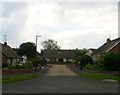
Rosemary Close, Steyning
A cul de sac off Rosemary Avenue that was built in the 1960s.
Image: © Simon Carey
Taken: 15 May 2016
0.04 miles
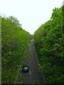
4
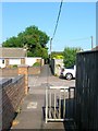
Public Footpath, Steyning
A very old right of way that originally ran over open fields to a detached portion of Steyning called Spratt's Marsh located in the shadows of Bramber Castle. The path has remained despite development, a footbridge was built over the railway in 1861, Holland Road and Castle Way follow the route and this path has been laid between Goring Road and Roman Road. Here it crosses the southern tip of Rosemary Avenue.
Image: © Simon Carey
Taken: 5 Jun 2016
0.05 miles
5
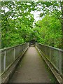
Footbridge, Steyning
Carrying an old right of way over Steyning By-Pass though the bridge originally carried pedestrians over the Shoreham-Christ's Hospital railway that operated from 1861 to 1966. The by-pass was opened in 1981. This view looks towards King's Barn Villas.
Image: © Simon Carey
Taken: 15 May 2016
0.05 miles
6
Steyning By-Pass
Viewed from the pedestrian footbridge that links King's Barn Villas to Goring Road and looking towards the road bridge carrying King's Barn Lane. Both bridges were originally built to carry traffic over the railway which closed in 1966. The by-pass was opened in 1981.
Image: © Simon Carey
Taken: 15 May 2016
0.07 miles
7
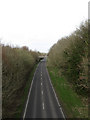
Steyning By-Pass
Viewed from the footbridge that links King's Barn Villas with Goring Road. This part of the by-pass was built along the trackbed of the former Shoreham-Horsham railway line that operated between 1861-1966. The road was constructed in the mid 1980s to reduce congestion in Steyning, Bramber and Upper Beeding. The bridge in the distance carries King's Barn Lane over the A283.
Image: © Simon Carey
Taken: 8 Mar 2009
0.08 miles
8
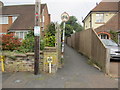
Path to Goring Road
Public footpath 2729.
Image: © Peter Holmes
Taken: 28 Sep 2013
0.08 miles
9
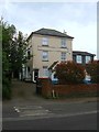
The Firs, Jarvis Lane, Steyning
Built as the Railway Inn probably in the 1860s when the Shoreham-Christ's Hospital railway was opened. It ceased being a pub in the 1930s possibly due to being in competition with the Railway Hotel which was located on the opposite side of the road and thus slightly nearer the station, see Image It has since been converted into flats with the section facing the road called The Firs and a two storey dwelling to the rear named Rose cottage which still retains some old pub advertising on its external walls.
Image: © Simon Carey
Taken: 15 May 2016
0.09 miles
10
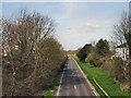
Steyning By Pass
viewed from Jarvis Lane
Image: © Paul Gillett
Taken: 10 Apr 2010
0.10 miles