IMAGES TAKEN NEAR TO
Chandlers Way, STEYNING, BN44 3NG
Introduction
This page details the photographs taken nearby to Chandlers Way, BN44 3NG by members of the Geograph project.
The Geograph project started in 2005 with the aim of publishing, organising and preserving representative images for every square kilometre of Great Britain, Ireland and the Isle of Man.

There are currently over 7.5m images from over14,400 individuals and you can help contribute to the project by visiting https://www.geograph.org.uk
Image Map
Images are licensed for reuse under creativecommons.org/licenses/by-sa/2.0
Notes
- Clicking on the map will re-center to the selected point.
- The higher the marker number, the further away the image location is from the centre of the postcode.
Image Listing (88 Images Found)
Images are licensed for reuse under creativecommons.org/licenses/by-sa/2.0
Image
Details
Distance
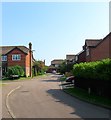
1
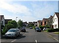
Chandlers Way, Steyning
A cul de sac off Newham Lane that was built in the 1980s.
Image: © Simon Carey
Taken: 29 May 2016
0.02 miles
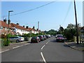
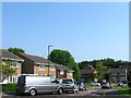
2
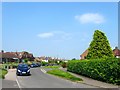
Newham Lane, Steyning
Originally the centuries old western route of the town of Steyning now little more than a narrow access route up onto the Downs. Initially only Newham Farm existed along the lane but the road began to be developed after the Second World War and was largely completed by the end of the 1970s.
Image: © Simon Carey
Taken: 5 Jun 2016
0.05 miles
3
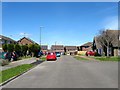
Hills Road, Steyning
A residential road that meanders between Ingram Road to the south and Newham Lane to the north that was not developed until the 1970s on the site of a former nursery thus connecting two separate residential developments.
Image: © Simon Carey
Taken: 1 May 2016
0.06 miles
5
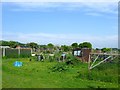
Rublees Allotments, Steyning
Located to the west of Image there have been allotments on this site since at least 1911. Of the two sets of allotments within Steyning these are the most popular due to its more fertile soil.
Image: © Simon Carey
Taken: 29 May 2016
0.08 miles
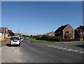
6
Laines Road, Steyning
A residential road that runs south from Newham Lane to Combe Road that was built in the late 1940s.
Image: © Simon Carey
Taken: 5 Jun 2016
0.08 miles
7
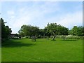
Community Orchard, Memorial Playing Field, Steyning
Tucked away in the south west corner of Image is a community orchard begun in 2014 using a mixture of existing trees and newly planted ones. An orchard was originally located here part of a nursery that occupied a field to the west of the cricket pitch. The nursery closed sometime in the 1970s and the land was acquired by the council as an extension to the recreation ground. Some of the trees remained but the area became overgrown until 2014 when locals decided to revive the orchard.
Image: © Simon Carey
Taken: 29 May 2016
0.09 miles
8
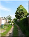
Private Track, Steyning
Running between Coombe Road and Newham Lane the track provides access for the garages to the rear of houses in Laines Road.
Image: © Simon Carey
Taken: 29 May 2016
0.11 miles
9
Godstalls Lane, Steyning
A cul de sac off Newham Lane that was developed around 1990 on the site of Whitcombe's Nursery. The turning on the left is Image
Image: © Simon Carey
Taken: 5 Jun 2016
0.11 miles
10
Newham Close, Steyning
A cul de sac off Newham Lane that was built in the 1970s on the site of Newham Farm. The farm is marked on the 1961 OS map but had become a depot by the 1971 edition and had been developed by 1978.
Image: © Simon Carey
Taken: 5 Jun 2016
0.12 miles