IMAGES TAKEN NEAR TO
Roman Road, STEYNING, BN44 3FN
Introduction
This page details the photographs taken nearby to Roman Road, BN44 3FN by members of the Geograph project.
The Geograph project started in 2005 with the aim of publishing, organising and preserving representative images for every square kilometre of Great Britain, Ireland and the Isle of Man.

There are currently over 7.5m images from over14,400 individuals and you can help contribute to the project by visiting https://www.geograph.org.uk
Image Map
Images are licensed for reuse under creativecommons.org/licenses/by-sa/2.0
Notes
- Clicking on the map will re-center to the selected point.
- The higher the marker number, the further away the image location is from the centre of the postcode.
Image Listing (81 Images Found)
Images are licensed for reuse under creativecommons.org/licenses/by-sa/2.0
Image
Details
Distance
2
Path to Goring Road
Public footpath 2729.
Image: © Peter Holmes
Taken: 28 Sep 2013
0.03 miles
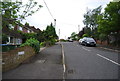
3
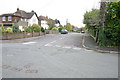
Castle Way
Looking east along Castle Way at junction with Roman Road
Image: © Bob Parkes
Taken: 2 Oct 2007
0.04 miles
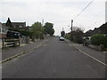
4
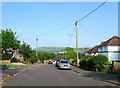
Castle Way, Steyning
A residential road running between Roman Road and King's Stone Avenue that had been laid out by 1932, developed on the southern side by 1946 and on the northern side by the beginning of the 1960s. Truleigh Hill can be seen in the distance. Originally Castle Field a part of Upper Beeding's Kings Barn tithing that was transferred to Steyning in the 1980s.
Image: © Simon Carey
Taken: 5 Jun 2016
0.05 miles
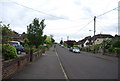
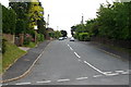
7
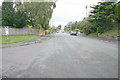
Roman Road
Roman Road at junction with Castle Lane looking north
Image: © Bob Parkes
Taken: 2 Oct 2007
0.07 miles
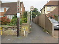
8
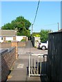
Public Footpath, Steyning
A very old right of way that originally ran over open fields to a detached portion of Steyning called Spratt's Marsh located in the shadows of Bramber Castle. The path has remained despite development, a footbridge was built over the railway in 1861, Holland Road and Castle Way follow the route and this path has been laid between Goring Road and Roman Road. Here it crosses the southern tip of Rosemary Avenue.
Image: © Simon Carey
Taken: 5 Jun 2016
0.07 miles
9
Roman Road
Looking south along Roman Road from the junction with Kings Barn Lane
Image: © Bob Parkes
Taken: 30 May 2005
0.07 miles
10
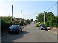
Roman Road, Steyning
The southern end of the road viewed from near the junction with Castle Lane. The northern part of the road as far as Castle Way had been laid out by 1932 with this section added later and developed by 1946. Originally part of Upper Beeding's Kings barn tithing that was transferred to Steyning in the 1980s.
Image: © Simon Carey
Taken: 5 Jun 2016
0.08 miles