IMAGES TAKEN NEAR TO
Chanctonbury Ring Road, STEYNING, BN44 3DP
Introduction
This page details the photographs taken nearby to Chanctonbury Ring Road, BN44 3DP by members of the Geograph project.
The Geograph project started in 2005 with the aim of publishing, organising and preserving representative images for every square kilometre of Great Britain, Ireland and the Isle of Man.

There are currently over 7.5m images from over14,400 individuals and you can help contribute to the project by visiting https://www.geograph.org.uk
Image Map
Images are licensed for reuse under creativecommons.org/licenses/by-sa/2.0
Notes
- Clicking on the map will re-center to the selected point.
- The higher the marker number, the further away the image location is from the centre of the postcode.
Image Listing (60 Images Found)
Images are licensed for reuse under creativecommons.org/licenses/by-sa/2.0
Image
Details
Distance
1
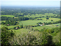
View from Chanctonbury Hill
Taken from below the eastern side of the ring with Malthouse Cottages and Hollow Way Cottages to the centre right. See Image for the full story of a former settlement that occupied that site.
Image: © Simon Carey
Taken: 2 Oct 2008
0.01 miles
2

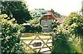
View to Malthouse Cottage
This was taken from a track with no official status along the bottom of Chalkpit Wood. The corner of a reservoir is at the front of the picture.
Image: © Shazz
Taken: 3 Sep 2011
0.01 miles
4
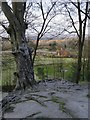
A view from Chalkpit Wood
Looking out towards Malthouse Cottages. The tree in the foreground is the one seen in: Image
Image: © Stefan Czapski
Taken: 5 Apr 2016
0.01 miles
5
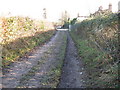
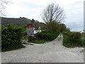
Bridleway to Malthouse Cottages
The cottages are at the end of Chanctonbury Ring Road.
Image: © Dave Spicer
Taken: 2 Jan 2011
0.01 miles
7
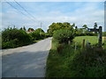
Southern end of Chanctonbury Ring Road
There is a bridleway off to the left.
Image: © Shazz
Taken: 3 Sep 2011
0.02 miles
8
View from near Chanctonbury Ring
Great Barn Farm is on the right. The houses are on Chanctonbury Ring Road, which degenerates to a steep bridleway up Wiston Bostal to the top of the downs.
Image: © Robin Webster
Taken: 27 Jun 2019
0.03 miles
9
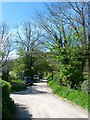
Chanctonbury Ring Road
The highway ends at the entrance to a covered reservoir just beyond the walkers in the distance. After that it becomes a track called Wiston Bostal. The track on the left heads to Great Barn Farm carrying a public footpath that heads east to Steyning.
Image: © Simon Carey
Taken: 1 May 2016
0.04 miles
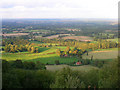
10
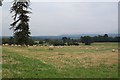
The fields of Great Barn Farm, Wiston
The ornamental trees in the fields of Great Barn Farm alongside Chanctonbury Ring Road show that they were once part of Wiston Park. The ancient manor of Wiston passed, by marriage, into the Goring family in 1740 and by the mid 19th century they owned most of the parish, as well as large estates in other parishes. In 1760 Charles Goring planted the famous beech trees on Chanctonbury Ring - they were blown down in the severe storm of October 1987. After the second world war most of the park was converted to agriculture. The house itself is now a conference centre run by the Foreign Office.
Image: © Ron Strutt
Taken: 10 Sep 2005
0.06 miles