IMAGES TAKEN NEAR TO
Elm Grove Lane, STEYNING, BN44 3BW
Introduction
This page details the photographs taken nearby to Elm Grove Lane, BN44 3BW by members of the Geograph project.
The Geograph project started in 2005 with the aim of publishing, organising and preserving representative images for every square kilometre of Great Britain, Ireland and the Isle of Man.

There are currently over 7.5m images from over14,400 individuals and you can help contribute to the project by visiting https://www.geograph.org.uk
Image Map
Images are licensed for reuse under creativecommons.org/licenses/by-sa/2.0
Notes
- Clicking on the map will re-center to the selected point.
- The higher the marker number, the further away the image location is from the centre of the postcode.
Image Listing (527 Images Found)
Images are licensed for reuse under creativecommons.org/licenses/by-sa/2.0
Image
Details
Distance
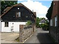
1
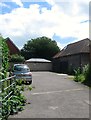
Barn, Elm Grove Lane, Steyning
An old timber barn off Elm Grove Lane that is located to the rear of properties on High Street, a reminder of the times when beyond the shops and houses on the main street were open fields.
Image: © Simon Carey
Taken: 2 Jul 2016
0.00 miles
2
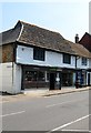
54, High Street, Steyning
Currently home to Bunce's hardware store. The gate on the left leads to a mews development called Borough Gates.
Image: © Simon Carey
Taken: 29 May 2016
0.01 miles
3
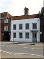
56, High Street, Steyning
Yet another former late medieval Wealden hall house that has been refronted in brick during the 18th century. Currently used as offices by a chartered ecologist.
Image: © Simon Carey
Taken: 29 May 2016
0.01 miles
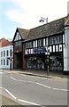
4
58-62, High Street, Steyning
Originally a timber framed building from the 16th century that was built with three storeys. The building was refronted in the 18th century. Number 58 on the right is now a private residence accessed via the carriageway on the extreme right though a former door can be made out in the brickwork to its left. Numbers 60 and 62 are still in commercial use mainly as offices though the ground floor of the latter is used as a shop. The sign on the left belongs to Image whilst in the distance is Image
Image: © Simon Carey
Taken: 29 May 2016
0.01 miles
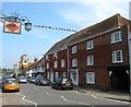
5
66, High Street, Steyning
Located on the southern corner of Elm Grove Lane and dating back to the 17th century where it was originally built as a timber framed house. Currently occupied by Truffles a local bakery chain.
Image: © Simon Carey
Taken: 29 May 2016
0.01 miles
6
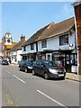
64, High Street, Steyning
Occupied by Martins the newsagent but like many buildings on the street it originated as a late medieval timber framed house.
Image: © Simon Carey
Taken: 29 May 2016
0.02 miles
8
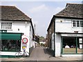
Elm Grove Lane
This narrow lane was known as Newman's Lane in 1911 and the Back Lane in 1791. Given that streets usually outlast buildings this lane may well have existed in the 14th century.
Image: © Andy Potter
Taken: 9 Jun 2007
0.02 miles
9

Post box, Steyning post office
Unusually, this appears to be simply a slab of concrete or stone painted red, and carries no monarch's ideograph.
Image: © Christopher Hilton
Taken: 24 Jan 2015
0.02 miles
10
Grove House, Elm Grove Lane, Steyning
Belonging to Bowers & Wilkins, see Image, and used as offices. Previously the site of a builders yard.
Image: © Simon Carey
Taken: 2 Jul 2016
0.02 miles