IMAGES TAKEN NEAR TO
Horsham Road, STEYNING, BN44 3AA
Introduction
This page details the photographs taken nearby to Horsham Road, BN44 3AA by members of the Geograph project.
The Geograph project started in 2005 with the aim of publishing, organising and preserving representative images for every square kilometre of Great Britain, Ireland and the Isle of Man.

There are currently over 7.5m images from over14,400 individuals and you can help contribute to the project by visiting https://www.geograph.org.uk
Image Map
Images are licensed for reuse under creativecommons.org/licenses/by-sa/2.0
Notes
- Clicking on the map will re-center to the selected point.
- The higher the marker number, the further away the image location is from the centre of the postcode.
Image Listing (20 Images Found)
Images are licensed for reuse under creativecommons.org/licenses/by-sa/2.0
Image
Details
Distance
1
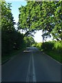
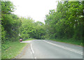
Horsham Road
The B2135 viewed from near the junction with Wappingthron Farm Lane. The road connects Steyning to the A24 near Knepp Castle via Partridge Green. The route had been established by 1724 and was turnpiked in 1764 forming the main route from Steyning to London via Horsham and Dorking.
Image: © Simon Carey
Taken: 2 Jul 2016
0.03 miles
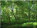
2
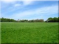
The Peat Field
The name of the field according to Steyning's 1840 tithe map that has been merged with Image to the south to form a larger unit. Quarry House can be seen beyond the field.
Image: © Simon Carey
Taken: 8 May 2016
0.14 miles
3
Limeshaw Cottages, Horsham Road
There are three cottages here though number one which is located to the rear has now been renamed Meadow Cottage. Named after the small wood to their immediate rear called Limes Shaw which lined the western side of a large field called Great Limes. Viewed from Horsham Road.
Image: © Simon Carey
Taken: 2 Jul 2016
0.15 miles
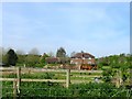
4
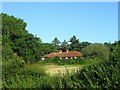
Commons Croft
The name of the field according to Steyning's 1840 tithe map that is now part of the grounds of a house called Milindy visible on the right.
Image: © Simon Carey
Taken: 2 Jul 2016
0.16 miles
5
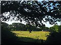
Ten Acres
The name of the field according to Steyning's 1840 tithe map most of which is now wooded. The planting appears to have occurred between the two wars. It is bounded by Horsham Road to the west and north and Image to the east.
Image: © Simon Carey
Taken: 2 Jul 2016
0.17 miles
6
Nash Vineyard
Built in the last twenty years though it hasn't been a vineyard for at least a decade. Built on a former open field called House Mead and located to the north of Nash Farm. To the east is Image
Image: © Simon Carey
Taken: 8 May 2016
0.17 miles
8
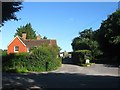
Red House, Horsham Road
Located at the junction of the B2135 and Wappingthorn Farm Lane. Built sometime in the 19th century and predates the current Wappingthorn Farm.
Image: © Simon Carey
Taken: 2 Jul 2016
0.18 miles
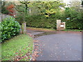
10
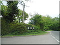
The entrance to Wappingthorn on Horsham Road
Image: © David Howard
Taken: 19 May 2013
0.19 miles