IMAGES TAKEN NEAR TO
Kingsland Close, SHOREHAM-BY-SEA, BN43 6LT
Introduction
This page details the photographs taken nearby to Kingsland Close, BN43 6LT by members of the Geograph project.
The Geograph project started in 2005 with the aim of publishing, organising and preserving representative images for every square kilometre of Great Britain, Ireland and the Isle of Man.

There are currently over 7.5m images from over14,400 individuals and you can help contribute to the project by visiting https://www.geograph.org.uk
Image Map
Images are licensed for reuse under creativecommons.org/licenses/by-sa/2.0
Notes
- Clicking on the map will re-center to the selected point.
- The higher the marker number, the further away the image location is from the centre of the postcode.
Image Listing (27 Images Found)
Images are licensed for reuse under creativecommons.org/licenses/by-sa/2.0
Image
Details
Distance
1
Edwards, Brighton Road
Formerly BOC Edwards now an independent entity. A bit of an optical illusion here as the far building, Barnes DAF, cannot be accessed from Brighton Road as it is separated by the railway line. Furthermore, it was roughly at this point that the former sidings that served Kingston Wharf left the line then descended at 1 in 82 gradient underneath a bridge that carried the A259 over the track. Built in the 1840s, redesigned in 1938 they were pulled up in 1968 and everything demolished soon after.
Image: © Simon Carey
Taken: 1 Feb 2009
0.13 miles
2
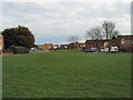
Green in William Road
In Kingston by Sea
Image: © Paul Gillett
Taken: 24 Jan 2010
0.13 miles
3
Lidl, Brighton Road, Shoreham By Sea
Recently opened on the site of Malthouse Trading Estate.
Image: © Simon Carey
Taken: 24 May 2020
0.15 miles
4
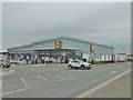
Shoreham-by-Sea, Lidl
Supermarket on Brighton Road.
Image: © Mike Faherty
Taken: 7 Apr 2018
0.16 miles
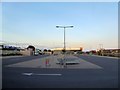
5
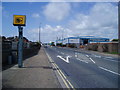
Speed camera A259 Brighton Road
Looking west towards Shoreham.
Image: © Peter Holmes
Taken: 1 May 2008
0.17 miles
6
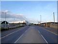
Brighton Road, Shoreham By Sea
Prior to 1971 the road rose to bridge the sidings that served Kingston Railway Wharf to the right. Much has now changed with a newish Aldi supermarket on the right and the former wharves on the left about to be redeveloped. The road is the A259.
Image: © Simon Carey
Taken: 24 May 2020
0.17 miles

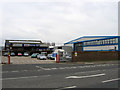
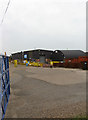
8
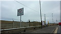
Entrance to EMR Shoreham (Scrap Metal) Off Brighton Road (A259)
Image: © Richard Cooke
Taken: 5 Jun 2018
0.18 miles
9
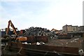
Scrapyard, Railway Wharf
The only unit operating on the former railway wharf, attempts at expansion meet much opposition from residents in Shoreham Beach who object to mountains of scrap such as this, Image
Image: © Simon Carey
Taken: 1 Feb 2009
0.19 miles