IMAGES TAKEN NEAR TO
Ropetackle, SHOREHAM-BY-SEA, BN43 5ER
Introduction
This page details the photographs taken nearby to Ropetackle, BN43 5ER by members of the Geograph project.
The Geograph project started in 2005 with the aim of publishing, organising and preserving representative images for every square kilometre of Great Britain, Ireland and the Isle of Man.

There are currently over 7.5m images from over14,400 individuals and you can help contribute to the project by visiting https://www.geograph.org.uk
Image Map
Images are licensed for reuse under creativecommons.org/licenses/by-sa/2.0
Notes
- Clicking on the map will re-center to the selected point.
- The higher the marker number, the further away the image location is from the centre of the postcode.
Image Listing (347 Images Found)
Images are licensed for reuse under creativecommons.org/licenses/by-sa/2.0
Image
Details
Distance
6
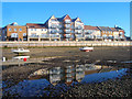
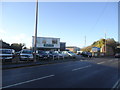
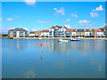
Ropetackle
Closer view of the newly developed area of the waterfront at Shoreham. Proposed in 1997 and completed by 2005 it was the precursor to other residential developments along the river on former wharves or derelict sites. Taken from the river at low tide when a shingle bank allows access.
Image: © Simon Carey
Taken: 7 Dec 2008
0.06 miles
7
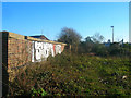
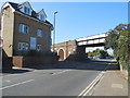
Former Railway Bridge
Taking the former Shoreham-Horsham line over the A283 towards the junction with the West Coastway. The line opened in 1861 and closed in 1966 though section between Shoreham and Beeding Cement Works remained open until 1981. The bridge has since been demolished with just the western parapet remaining whilst the eastern side is now occupied by car showroom.
Image: © Simon Carey
Taken: 7 Dec 2008
0.06 miles
8
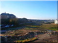
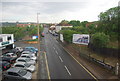
Ready for Development
Taken from the embankment of the former Shoreham-Horsham line the small industrial unit that once occupied this spot has been demolished and is awaiting redevelopment. The railway and its bridge over the Adur is to the left with the northern edge of the Ropetackle development beyond it. A similar riverfront project may well be planned for this part.
Image: © Simon Carey
Taken: 7 Dec 2008
0.06 miles
9
Ropetackle
Viewed from the Sea Scouts' landing stage on the western bank of the river. Constructed a few years ago on the site of a former council depot.
Image: © Simon Carey
Taken: 8 Apr 2008
0.06 miles
10
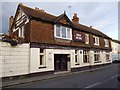
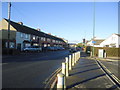
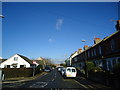
The Swiss Cottage, Shoreham-by-Sea
Pub in Old Shoreham Road, overlooking West Lake.
Image: © David960
Taken: 13 Aug 2014
0.07 miles