IMAGES TAKEN NEAR TO
Ship Street, SHOREHAM-BY-SEA, BN43 5DY
Introduction
This page details the photographs taken nearby to Ship Street, BN43 5DY by members of the Geograph project.
The Geograph project started in 2005 with the aim of publishing, organising and preserving representative images for every square kilometre of Great Britain, Ireland and the Isle of Man.

There are currently over 7.5m images from over14,400 individuals and you can help contribute to the project by visiting https://www.geograph.org.uk
Image Map
Images are licensed for reuse under creativecommons.org/licenses/by-sa/2.0
Notes
- Clicking on the map will re-center to the selected point.
- The higher the marker number, the further away the image location is from the centre of the postcode.
Image Listing (547 Images Found)
Images are licensed for reuse under creativecommons.org/licenses/by-sa/2.0
Image
Details
Distance
1
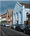
Shoreham-by-Sea Snooker Club, West Street
"This Classical-style chapel was opened in 1862 for the Primitive Methodist community. When a new chapel opened in 1879, it became a Salvation Army hall. Since the 1930s it has been home to the Shoreham Snooker Club." - Quotation from this http://www.myprimitivemethodists.org.uk/page/shoreham_primitive_methodist_chapel?path=0p9p126p.
Image: © Jim Osley
Taken: 7 Oct 2016
0.02 miles
2
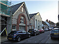
West Street Studios (near) and Shoreham Snooker Club
Looking chapel-like, but there is no mapped indication that the near one was. However, the far light coloured snooker club was a Primitive Methodist chapel from 1862 to 1879, when replaced by a new High Street chapel. It then became a Salvation Army hall until the 1930s.
Image: © Robin Webster
Taken: 21 Jan 2023
0.02 miles
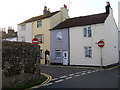
3
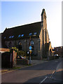
St Peters Church, Ship Street
Roman Catholic church built in 1875. Not sure if it is still used as a place of worship as it is no longer marked on the map. The building lies between Ship Street and John Street.
Image: © Simon Carey
Taken: 15 Feb 2008
0.02 miles
4
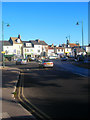
High Street
Viewed from the western approach to Norfolk Bridge which carries the A259 over the River Adur. The roundabout forms the junction with Old Shoreham Road, the A283.
Image: © Simon Carey
Taken: 7 Dec 2008
0.03 miles
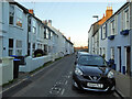
5
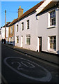
Ship Street
Taken from its northern junction with North Street. New Shoreham was a planned medieval new town whose boundaries can still be discerned today. The flint walls in particular marking out the limits of the streets.
Image: © Simon Carey
Taken: 12 Nov 2006
0.03 miles
6
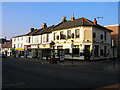
Suters Yard, High Street
Formerly the Schooner on the corner of Ship Street. The small cottage at the far end of the row dates from 1706 and is currently occupied by an Indian takeaway.
Image: © Simon Carey
Taken: 15 Feb 2008
0.04 miles
8
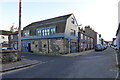
Building, corner of West Street and North Street, Shoreham
Unlisted, looking altered, but the flanking single cottage to the left and five to the right are grade II, late 18th century. The five have a modern tablet claiming 'circa 1776'. Were the cottages housing for the workers in the corner building? Local historians have surmised this was 'probably used for a number of purposes including a sail loft but certainly incorporated the tar house'. West Street north from here was used as a rope walk, the rope would be tarred.
Image: © Robin Webster
Taken: 21 Jan 2023
0.05 miles
9
Cottages, John Street
Shoreham was laid out as a new town in the 12th century and the street pattern to the north of the High Street pretty much follows the original layout. That to the south was washed away by coastal erosion.
Image: © Simon Carey
Taken: 15 Feb 2008
0.05 miles
10
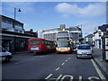
High Street, (A259)
The new Ropetackle development can be glimpsed at behind the 11.20 Shoreham to Rottingdean No2 bus.
Image: © Peter Holmes
Taken: 1 Mar 2008
0.05 miles