IMAGES TAKEN NEAR TO
BN4 2RP
Introduction
This page details the photographs taken nearby to BN4 2RP by members of the Geograph project.
The Geograph project started in 2005 with the aim of publishing, organising and preserving representative images for every square kilometre of Great Britain, Ireland and the Isle of Man.

There are currently over 7.5m images from over14,400 individuals and you can help contribute to the project by visiting https://www.geograph.org.uk
Image Map
Images are licensed for reuse under creativecommons.org/licenses/by-sa/2.0
Notes
- Clicking on the map will re-center to the selected point.
- The higher the marker number, the further away the image location is from the centre of the postcode.
Image Listing (17 Images Found)
Images are licensed for reuse under creativecommons.org/licenses/by-sa/2.0
Image
Details
Distance
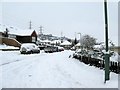
1
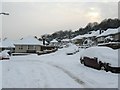
Oakdene Close Mile Oak
Oakdene Close and all the other roads west of the central Mile Oak Road were built from the 1950's onwards.
Image: © Dave Spicer
Taken: 2 Dec 2010
0.02 miles
2
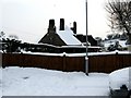
Pergola in the Mile Oak pub gardens
The village of Mile Oak is rumoured to have got its name by having an Oak tree one mile from the Stags Head in Portslade Old Village. The pub itself was not built until the early fifties.
Image: © Dave Spicer
Taken: 2 Dec 2010
0.04 miles
3
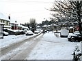
South along Mile Oak Road, Mile oak
The Mile Oak pub is on the right.
Image: © Dave Spicer
Taken: 2 Dec 2010
0.08 miles
4
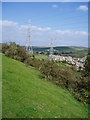
Access land above Mile Oak
View from Sussex Border Path over access land with Mile Oak and A27 embankment in the distance.
Image: © Peter Holmes
Taken: 6 Oct 2007
0.08 miles
5
North along Oakdene Crescent Mile Oak
Oakdene Crescent curves to the left, Oakdene Gardens leads off to the right.
Image: © Dave Spicer
Taken: 2 Dec 2010
0.08 miles
6
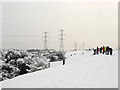
Sledging, Southwick Hill
A popular spot for those of all ages taking advantage of a steep slope that heads down towards Mile Oak. On the extreme right in the distance the person in view had tied a rope to the back of a land rover and was being pulled around the hill like a waterskier, unfortunately going too quickly for me to catch him in the frame. Southwick Hill is owned by the National Trust and is open access around its peak.
Image: © Simon Carey
Taken: 2 Dec 2010
0.09 miles
7
Mile Oak in April
Picture didn't capture the howling northerly wind blowing along the top
Image: © Dave Spicer
Taken: 6 Apr 2008
0.10 miles
8
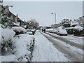
Mile Oak Road, Mile Oak
The houses on the immediate left were built on the site of the former Mile Oak Garage which closed down in the late 60's early 70's. With reference to the name Mile Oak Image the oak tree would have been near the first lamp post on the left.
Image: © Dave Spicer
Taken: 2 Dec 2010
0.11 miles
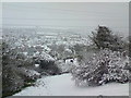
9
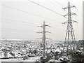
Mile Oak in the Snow
A suburb of Portslade that was gradually built up during the 20th century initially as a private development but from the 1960s as a large council enterprise to rehouse the waterside community at Portslade by Sea when that area was redeveloped. Viewed from Southwick Hill.
Image: © Simon Carey
Taken: 2 Dec 2010
0.16 miles
10
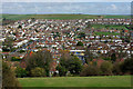
Mile Oak from Southwick Hill
The near road roughly in line with the view is Oakdeane Crescent, with a parade of shops opposite its junction with Mile Oak Road.
Image: © Robin Webster
Taken: 3 Apr 2010
0.20 miles