IMAGES TAKEN NEAR TO
Southdown Road, BRIGHTON, BN42 4FT
Introduction
This page details the photographs taken nearby to Southdown Road, BN42 4FT by members of the Geograph project.
The Geograph project started in 2005 with the aim of publishing, organising and preserving representative images for every square kilometre of Great Britain, Ireland and the Isle of Man.

There are currently over 7.5m images from over14,400 individuals and you can help contribute to the project by visiting https://www.geograph.org.uk
Image Map
Images are licensed for reuse under creativecommons.org/licenses/by-sa/2.0
Notes
- Clicking on the map will re-center to the selected point.
- The higher the marker number, the further away the image location is from the centre of the postcode.
Image Listing (64 Images Found)
Images are licensed for reuse under creativecommons.org/licenses/by-sa/2.0
Image
Details
Distance
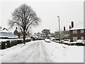
1

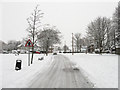
Southdown Road
Side road linking The Green with Southwick Street that follows the course of an old farm lane. It was known by this name by 1899.
Image: © Simon Carey
Taken: 2 Dec 2010
0.02 miles
2

34 - 44 The Green
Group of Edwardian semi-detached villas overlooking The Green.
Image: © Ian Capper
Taken: 21 Jan 2022
0.09 miles
3
The Green
Name of the B2167 as it skirts the eastern side of open space also known as The Green before splitting into two at the crossroads, Cross Road to the west and Southview Road to the north both heading towards the Old Shoreham Road, the A270.
Image: © Simon Carey
Taken: 2 Dec 2010
0.09 miles
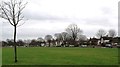
4
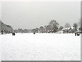
The Green
The name of the open space in the centre of Southwick that was once common land before the local council purchased it in 1903 for use as a recreational area. This looks from the very northern tip of the green.
Image: © Simon Carey
Taken: 2 Dec 2010
0.09 miles
5
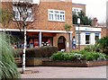
Bank and travel agency, Southwick
The bank has belonged to Barclays at least since the nineteen seventies. The travel agency on the other hand has been owned by a number of companies including Blue Star Travel and Wakefield Fortune, though it has belonged to the Co-op for some years.
Image: © nick macneill
Taken: 20 Jan 2012
0.09 miles
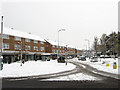
6
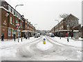
Southwick Square
Viewed from The Green. Southwick's main shopping street was purpose built in 1962 as part of a major regeneration scheme replacing the old shopping area which ran along Albion Street, the A259. The consequence was to move the centre of Southwick away from the seafront where it had shifted from the mid 19th century back to the medieval centre which lay surrounding The Green, the old village common. The 'square' itself is at the eastern end before narrowing to a conventional street as it heads west.
Image: © Simon Carey
Taken: 2 Dec 2010
0.10 miles
7
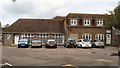
Southwick Community Centre
The Southwick Centre is used for conferences, exhibitions, meetings, social events, recreational activities, education/training, workshops or seminars and the performing arts.
It offers a wide range of rooms of varying sizes, facilities and capacities together with a modern fully equipped theatre http://www.southwickcommunitycentre.org.uk/index.htm
Image: © Paul Gillett
Taken: 17 Sep 2011
0.10 miles
9
Roman Crescent
Named after a Roman villa which once existed in Southwick Street between the 1st and 4th centuries. The route is also quite ancient being the start of the road from the northern tip of The Green to the village of Portslade. Hope Cottages are on the right.
Image: © Simon Carey
Taken: 2 Dec 2010
0.10 miles
10
Southwick Square
Running between Southwick Street and The Green, Southwick's main shopping street was purpose built in 1962 as part of a major regeneration scheme replacing the old shopping area which ran along Albion Street, the A259. The consequence was to move the centre of Southwick away from the seafront where it had shifted from the mid 19th century back to the medieval centre which lay surrounding The Green, the old village common. The 'square' itself is at the eastern end before narrowing to a conventional street as it heads west.
Image: © Simon Carey
Taken: 2 Dec 2010
0.10 miles