IMAGES TAKEN NEAR TO
Seaview Estate, BRIGHTON, BN42 4AS
Introduction
This page details the photographs taken nearby to Seaview Estate, BN42 4AS by members of the Geograph project.
The Geograph project started in 2005 with the aim of publishing, organising and preserving representative images for every square kilometre of Great Britain, Ireland and the Isle of Man.

There are currently over 7.5m images from over14,400 individuals and you can help contribute to the project by visiting https://www.geograph.org.uk
Image Map
Images are licensed for reuse under creativecommons.org/licenses/by-sa/2.0
Notes
- Clicking on the map will re-center to the selected point.
- The higher the marker number, the further away the image location is from the centre of the postcode.
Image Listing (107 Images Found)
Images are licensed for reuse under creativecommons.org/licenses/by-sa/2.0
Image
Details
Distance
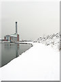
1
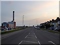
Albion Street, Southwick
The A259 heading westwards with Shoreham Power Station to the left and the Seaview Estate to the right.
Image: © Simon Carey
Taken: 9 May 2020
0.02 miles
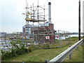
2
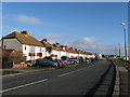
Seaview Estate, Albion Street
The estate starts from here and stretches to the junction with The Gardens which marks the eastern limit of Southwick. The name is a bit of a misnomer as the initial view is of the power station and a new steel terminal. Albion Street is the name of the A259 as it passes through Southwick, it changes to Fishersgate Terrace as it enters Fishersgate.
Image: © Simon Carey
Taken: 25 Dec 2009
0.03 miles
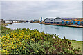
3
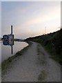
Track, Shoreham Harbour
Running along the northern side of The Canal from Shoreham Oil Terminal to North Canal Bank.
Image: © Simon Carey
Taken: 9 May 2020
0.03 miles
4
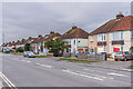
Seaview Estate
c.1920s housing on Albion Street.
Image: © Ian Capper
Taken: 21 Jan 2022
0.03 miles
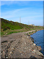
5
North Canal Bank
An undeveloped section of Shoreham Harbour opposite the power station that has public access via steps and path. Often used by anglers and dog walkers. Small low lying cliffs are on the right and are a survivor of what the coast from here to Brighton may have once looked like.
Image: © Simon Carey
Taken: 2 Dec 2010
0.04 miles
7
Along Shoreham Harbour
Looking along Shoreham Harbour from Albion Street with the warehouse of Barrett Steel on the right.
Image: © Ian Capper
Taken: 21 Jan 2022
0.04 miles
8
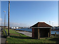
Shelter next to the A259
Not sure what this is for but it may be owned by the local water company. Next to Albion Street, the A259, and looking down on The Canal as it heads east to Aldrington Basin.
Image: © Simon Carey
Taken: 25 Dec 2009
0.05 miles
9
Former Sea Cliffs
The surface in the foreground has been laid to push back the waters edge and avoid erosion of the former low lying cliffs which carry the A259 coast road.
Image: © Simon Carey
Taken: 4 Apr 2008
0.05 miles
10
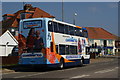
Coastliner 700, Southwick, Sussex
This service is scheduled to run along the sea-front, to Brighton. I like the matching colours of the bus, and surroundings.
Image: © Peter Trimming
Taken: 17 Apr 2010
0.06 miles