IMAGES TAKEN NEAR TO
Old Shoreham Road, BRIGHTON, BN41 1XS
Introduction
This page details the photographs taken nearby to Old Shoreham Road, BN41 1XS by members of the Geograph project.
The Geograph project started in 2005 with the aim of publishing, organising and preserving representative images for every square kilometre of Great Britain, Ireland and the Isle of Man.

There are currently over 7.5m images from over14,400 individuals and you can help contribute to the project by visiting https://www.geograph.org.uk
Image Map
Images are licensed for reuse under creativecommons.org/licenses/by-sa/2.0
Notes
- Clicking on the map will re-center to the selected point.
- The higher the marker number, the further away the image location is from the centre of the postcode.
Image Listing (64 Images Found)
Images are licensed for reuse under creativecommons.org/licenses/by-sa/2.0
Image
Details
Distance
1
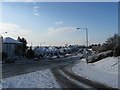
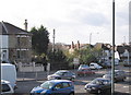
Old Shoreham Road
The section of the A270 between the junction with Hangleton Road, the A2038, and the junction with Hangleton Link Road, the A293. The road is an ancient east-west route following the course of a nearby Roman road and was until the early 1990s the main A27 trunk road. The dual carriageway was built in the early 1970s and runs from Hove Cemetery to Shoreham. See http://regencysociety-jamesgray.com/volume16/source/jg_16_156.html for an image of the same stretch taken from the other side of the road prior to road widening.
Image: © Simon Carey
Taken: 7 Jan 2010
0.02 miles
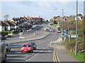
2
A270 Junction
A270 junction at Hangleton with the link road to the A27 Brighton Bypass.
Image: © Bob Parkes
Taken: 9 Nov 2007
0.02 miles
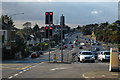
3
A270 Traffic Lights
One of the many sets of traffic lights on the A270 out of Brighton
Image: © Bob Parkes
Taken: 9 Nov 2007
0.02 miles
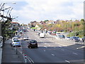
4
A270, Old Shoreham Road
Dual carriageway road through Hove. At traffic light controlled cross roads with Carlton Terrace (left) Hangleton Road (right).
Image: © Oast House Archive
Taken: 16 Oct 2010
0.04 miles
5
Suburban Mobile Phone Mast
Must have been built before the days of objections !
Image: © Bob Parkes
Taken: 9 Nov 2007
0.07 miles
6
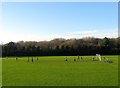
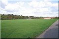
Benfield Valley Recreation Ground, Hove
Located to the immediate north of Old Shoreham Road, the A270. Originally the southern most field in the parish of Hangleton called Upper and Lower Dean according to its 1841 tithe map. In 1910 Benfield valley was converted into the West Hove Golf Course with the former club house located just out of shot to the left. The course remained until 1991 when construction of the Brighton By-Pass including the Hangleton Link Road, located beyond the trees where lamp posts can be made out, caused it to relocate north of the A27. The area south of Hangleton Lane was split between a Sainsbury's superstore and a new park. A group of friends have just started an eight-a-side match.
Image: © Simon Carey
Taken: 22 Dec 2016
0.08 miles
7
Playing Fields - Hangleton
The Playing Fields at Hangleton with the A270 in the distance.
Image: © Bob Parkes
Taken: 9 Nov 2007
0.08 miles
8
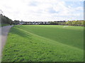
Playing Field, Benfield Valley
The valley is the name given to a strip of green that runs from the A270 northwards separating the suburbs of Portslade and Hangleton. It continues north of the by-pass until it rises near Dyke Farm. Prior to 1991 this was West Hove Golf Course which had been established in 1910 but had to relocate when the new by-pass split the old course in two. The southern end of the course which also contained the old clubhouse is now a playing field.
Image: © Simon Carey
Taken: 7 Jan 2010
0.10 miles
9
Playing Fields - Hangleton
The Playing Fields at Hangleton with Sainsbury's beyond
Image: © Bob Parkes
Taken: 9 Nov 2007
0.11 miles
10
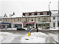
Shops, Carlton Terrace
Viewed from Hallyburton Road. The B2194 became Portslade's major shopping street from the 1930s having previously been a residential road.
Image: © Simon Carey
Taken: 2 Dec 2010
0.11 miles