IMAGES TAKEN NEAR TO
Clarendon Place, BN41 1BG
Introduction
This page details the photographs taken nearby to Clarendon Place, BN41 1BG by members of the Geograph project.
The Geograph project started in 2005 with the aim of publishing, organising and preserving representative images for every square kilometre of Great Britain, Ireland and the Isle of Man.

There are currently over 7.5m images from over14,400 individuals and you can help contribute to the project by visiting https://www.geograph.org.uk
Image Map (Loading...)


Getting Data...Please wait
Leaflet Map data © OpenStreetMap
Images are licensed for reuse under creativecommons.org/licenses/by-sa/2.0
Notes
- Clicking on the map will re-center to the selected point.
- The higher the marker number, the further away the image location is from the centre of the postcode.
Image Listing (173 Images Found)
Images are licensed for reuse under creativecommons.org/licenses/by-sa/2.0
Image
Details
Distance
1
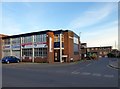
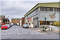
Clarendon Place, Portslade-By-Sea
A cul-de-sac heading south from North Street. The boarded up building is Image
The area between Station Road in the east, Church Road in the west and St Andrew's Road to north was once a community of tight knit terraced housing that made up the settlement of Portslade-By-Sea. The vast majority were demolished in the 1950s as slum housing and the area given over to business units and small factories. Only a few houses on the southern side of the A259 along with Albion Street remain of the former district.
Image: © Simon Carey
Taken: 17 May 2020
0.01 miles
2
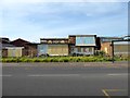
Belgrave Centre, Clarendon Place, Portslade-By-Sea
Originally a small cul-de-sac called Belgrave Square that was demolished in the 1950s and replaced by the current building which was opened in 1966 as a training centre for those with disabilities. Now boarded up awaiting demolition after plans were approved in April 2020 to build low cost housing on the site. Viewed from Wellington Road.
Image: © Simon Carey
Taken: 17 May 2020
0.02 miles
3
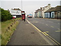
Wellington Road bus stop
Route 700, Coastliner to Brighton on A259.
Image: © Peter Holmes
Taken: 17 Mar 2012
0.02 miles
4
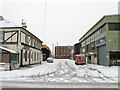
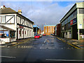
Camden Street
Small side street linking Wellington Road to North Street. The area here was once known as Copperas Gap and a small residential district sprung up during the Victorian period to service the growing industries based around the new port of Shoreham. Officially renamed as Portslade by Sea in 1896 the community persisted until the 1960s when many of the small terraced houses were pulled down and replaced with industrial units. The pub on the left is a survivor from those times, originally known as the Alexandra Inn, it is now the Harbour View.
Image: © Simon Carey
Taken: 2 Dec 2010
0.02 miles
5
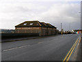
Camden Street
Originally a road of Victorian terraced housing, marked as Camden Place on the 1879 6 inch map, by the time of the 1932 25 inch map it had been renamed Camden Street. It now serves South Portslade Industrial Estate.
Image: © Ian Capper
Taken: 21 Jan 2022
0.03 miles
6
Former Showroom, Wellington Road
Not sure whether these are in use but are on the southern side of the A259 backing onto the timber yards below.
Image: © Simon Carey
Taken: 9 Dec 2007
0.03 miles
7
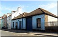
Camden Street, Portslade-by-Sea
A once residential street for those working in the gas works and other harbour industries now filled with warehouses and factories. The Harbour View, formerly the Alexandra Inn, the one survivor of the 1950s slum clearances.
Image: © Simon Carey
Taken: 9 Dec 2007
0.03 miles
8
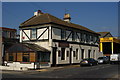
The Harbour View, Portslade, Sussex
Located at the end of Camden Street, at the junction with Wellington Road.
Image: © Peter Trimming
Taken: 17 Apr 2010
0.04 miles
9
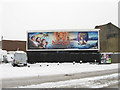
Who Left the Wardrobe Open?
Apt advertisement on Wellington Road, the A259, after 8-10 inches of snow were deposited on Brighton overnight. The billboard occupies the site of Belgrave Square built in the 1850s and demolished in the 1960s.
Image: © Simon Carey
Taken: 2 Dec 2010
0.04 miles
10
Former workshop, A259, Portslade
The workshop seems closed now, but during the seventies and eighties it was used by an Antiques restorer.
Image: © nick macneill
Taken: 2 Aug 2012
0.04 miles