IMAGES TAKEN NEAR TO
Maple Gardens, HOVE, BN3 7JU
Introduction
This page details the photographs taken nearby to Maple Gardens, BN3 7JU by members of the Geograph project.
The Geograph project started in 2005 with the aim of publishing, organising and preserving representative images for every square kilometre of Great Britain, Ireland and the Isle of Man.

There are currently over 7.5m images from over14,400 individuals and you can help contribute to the project by visiting https://www.geograph.org.uk
Image Map
Images are licensed for reuse under creativecommons.org/licenses/by-sa/2.0
Notes
- Clicking on the map will re-center to the selected point.
- The higher the marker number, the further away the image location is from the centre of the postcode.
Image Listing (94 Images Found)
Images are licensed for reuse under creativecommons.org/licenses/by-sa/2.0
Image
Details
Distance
1
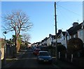
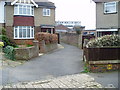
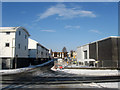
Maple Gardens, Hove
A residential road that links Elm Drive to Acacia Avenue that was developed in the 1930s.
Image: © Simon Carey
Taken: 5 Jan 2017
0.02 miles
2
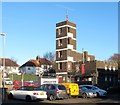
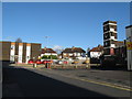
Drill Tower, Hove Fire Station, English Close, Hove
Located on the eastern side of the station whose offices are out of shot to the left. Built around 1963 it occupies the former trackbed of the Dyke Railway which operated from 1887 to 1938.
Image: © Simon Carey
Taken: 5 Jan 2017
0.03 miles
3
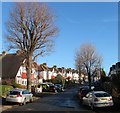
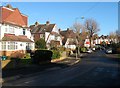
Elm Drive, Hove
A residential road that links Holmes Avenue to Hangleton Road that was developed in the 1930s in the northern part of the former parish of Aldrington.
Image: © Simon Carey
Taken: 5 Jan 2017
0.03 miles
4
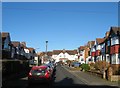
Acacia Avenue, Hove
A short residential road that links maple Gardens to Elm Drive that was developed in the 1930s in the northern end of the former parish of Aldrington.
Image: © Simon Carey
Taken: 5 Jan 2017
0.04 miles
5
Hove Fire Station
Situated at the northern end of English Close.
Image: © Dave Spicer
Taken: 1 Jan 2013
0.04 miles
6
Public footpath to Old Shoreham Road
From Maple Gardens.
Image: © Peter Holmes
Taken: 17 Mar 2012
0.04 miles
7
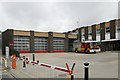
Hove fire station
Hove fire station, English Close, Hove, East Sussex with a Volvo pumping appliance outside.
Image: © Kevin Hale
Taken: 16 Jun 2007
0.05 miles
8
47-53, Elm Drive, Hove
The two pairs of semi-detached houses on the left were built in the 1930s and occupy the site of Gibbets Farm. Originally a barn where two labourers Edward Howell and James Rooke hid in 1792 to share the proceeds of the letters they had just robbed from a mail boy on the Old Shoreham Road in nearby Goldstone Bottom, now Hove Park. Both were soon identified, arrested and put on trail in Horsham where they were found guilty and sentenced to hang. Their bodies were gibbeted overlooking the scene of their crime where Rooke's mother would often be found waiting for the bones to drop so she could collect and give the body a proper burial. Tennyson's peom 'Rizpah' is alleged to have been based on the story.
Subsequently, the barn became known as Gibbets Barn which sometime in the mid 19th century had two cottages built next to it. One of the last tenants, Samuel Holmes, converted them into a single dwelling becoming the farmhouse of Gibbets Farm. The farm operated until 1930 when the land was sold for housing and subsequently demolished to make way for the houses in Elm Drive.
See
Barns, Gibbet Farm (Date unknown) - http://regencysociety-jamesgray.com/volume37/source/jg_37_107.html
Farmhouse, Gibbets Farm (1912) - http://regencysociety-jamesgray.com/volume37/source/jg_37_109.html
Image: © Simon Carey
Taken: 5 Jan 2017
0.05 miles
9
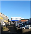
Serco, English Close, Hove
Offices of the outsourcing company is tucked away behind Image well back from the road. The building dates from the 1960s.
Image: © Simon Carey
Taken: 5 Jan 2017
0.05 miles
10
English Close
Small cul-de-sac off Old Shoreham Road filled with business units and Hove Fire Station. Prior to the early 1960s this area was a market garden and nursery.
Image: © Simon Carey
Taken: 7 Jan 2010
0.06 miles