IMAGES TAKEN NEAR TO
Torrance Close, HOVE, BN3 7JR
Introduction
This page details the photographs taken nearby to Torrance Close, BN3 7JR by members of the Geograph project.
The Geograph project started in 2005 with the aim of publishing, organising and preserving representative images for every square kilometre of Great Britain, Ireland and the Isle of Man.

There are currently over 7.5m images from over14,400 individuals and you can help contribute to the project by visiting https://www.geograph.org.uk
Image Map
Images are licensed for reuse under creativecommons.org/licenses/by-sa/2.0
Notes
- Clicking on the map will re-center to the selected point.
- The higher the marker number, the further away the image location is from the centre of the postcode.
Image Listing (97 Images Found)
Images are licensed for reuse under creativecommons.org/licenses/by-sa/2.0
Image
Details
Distance
1
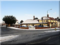
The Atlas
For many years a slightly dodgy pub called The Stadium but in the last year has been changed into a pub restaurant specialising in Italian food with another former section of the bar turned a cafe specialising in all day English breakfasts. Located at the junction of Old Shoreham Road and Holmes Avenue.
Image: © Simon Carey
Taken: 7 Jan 2010
0.02 miles
2
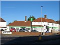
Hove, Co-op Food
At the corner of Old Shoreham Road and Holmes Avenue; formerly the Stadium Hotel.
Image: © Mike Faherty
Taken: 15 Sep 2018
0.03 miles
3

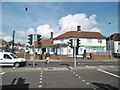
Looking across Old Shoreham Road towards "The Atlas"
"The Atlas" is a public house with a restaurant and a café. The café is seen here, viewed from the top of Amherst Crescent.
Image: © Shazz
Taken: 27 Jun 2011
0.03 miles
4
The Atlas Pub & Restaurant
In Old Shoreham Road at junction with Holmes Avenue, now with black framed windows and white walls - see previous photo Image
Image: © Peter Holmes
Taken: 17 Mar 2012
0.04 miles
5
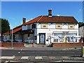
253, Old Shoreham Road, Hove
Originally opened in the 1930s as the Stadium Hotel and public house and for many years ideally situated for those wishing a quick tipple before or after a match at the Goldstone Ground which was ten minutes walk to the east. The ground's closure in 1997 was the beginning of the end for the pub which continued operating until 2015, the last six years as the Atlas, see Image, until finally closing. The building was converted into a small convenience store run by the Co-Op which opened in 2016.
Image: © Simon Carey
Taken: 5 Jan 2017
0.04 miles
6
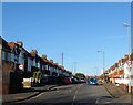
Holmes Avenue, Hove
A residential road that connects Old Shoreham Road to Hangleton Road that was built in stages during the 1930s. This section as far as the old parish boundary between Aldrington and West Blatchington had been completed by the early 1930s.
Image: © Simon Carey
Taken: 5 Jan 2017
0.04 miles
7
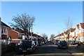
Cranmer Avenue, Hove
A residential street that links Weald Avenue to Holmes avenue that was developed in the 1930s in the north east corner of the former parish of Aldrington.
Image: © Simon Carey
Taken: 5 Jan 2017
0.04 miles
8

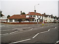
"The Atlas" at the junction of Old Shoreham Road and Holmes Avenue
Image: © Shazz
Taken: 27 Jun 2011
0.04 miles
9
The Atlas, formerly The Stadium, closed
Image: © Alex McGregor
Taken: 13 Aug 2014
0.04 miles
10
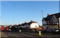
266-268, Old Shoreham Road, Hove
Located on the western side of the junction with Amherst Crescent. The buildings date from the 1930s with 268 being a local Post Office since at least the 1940s.
Image: © Simon Carey
Taken: 5 Jan 2017
0.05 miles