IMAGES TAKEN NEAR TO
Elm Drive, HOVE, BN3 7JL
Introduction
This page details the photographs taken nearby to Elm Drive, BN3 7JL by members of the Geograph project.
The Geograph project started in 2005 with the aim of publishing, organising and preserving representative images for every square kilometre of Great Britain, Ireland and the Isle of Man.

There are currently over 7.5m images from over14,400 individuals and you can help contribute to the project by visiting https://www.geograph.org.uk
Image Map
Images are licensed for reuse under creativecommons.org/licenses/by-sa/2.0
Notes
- Clicking on the map will re-center to the selected point.
- The higher the marker number, the further away the image location is from the centre of the postcode.
Image Listing (53 Images Found)
Images are licensed for reuse under creativecommons.org/licenses/by-sa/2.0
Image
Details
Distance
1
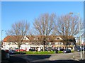
82-92, Elm Drive, Hove
Located at the junction with Rowan Avenue which heads off to the left whilst Elm Drive continues to the right, both part of a one way system between here and Hangleton Road. The parade of shops include a general store, dentist, Christian bookshop, Indian takeaway and a motor factors. Built in the mid 1930s on what was the northern end of the former parish of Aldrington.
Image: © Simon Carey
Taken: 5 Jan 2017
0.05 miles
3
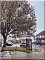
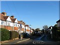
Rowan Avenue, Hove
A residential road that links Elm Drive to Hangleton Road that is northbound only, southbound traffic head down Elm Drive which runs parallel to the east. Built in the 1930s on land that was once part of the parish of Aldrington.
Image: © Simon Carey
Taken: 5 Jan 2017
0.08 miles
4
Footpath, Knoll Recreation Ground, Hove
Heading south east to join another that links Old Shoreham Road to Rowan Avenue that runs through the northern part of Hove Cemetery. The footpath here follows the trackbed of the former Dyke Railway that was opened in 1887 as an excursion route for tourists wishing to visit Devil's Dyke. The branch left the main west coast line at Aldrington (Originally known as Dyke Junction Halt) curving to the north, then west, then north again as it crossed open downland to a terminus situated next to Dyke Farm that was half a mile from the Dyke and required a walk up a steep gradient that was 200 foot below the summit. Two intermediate halts were added, the first in 1891 to serve Brighton & Hove Golf Club, called Golf Club Halt, and the other in 1933 to serve the newly built estates to the north which was called Rowan Halt. By then, however, the line was fast losing money to the motorbus trade which was able to drop visitors off right next to the Dyke and the line was closed on New Year's Eve 1938. The branch's alignment can be made out clearly north of the bypass but has largely been filled in to the south.
Image: © Simon Carey
Taken: 5 Jan 2017
0.08 miles
5
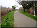
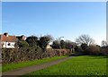
Path to Knoll Recreation Ground
Route of the old railway line to Devils Dyke curving behind houses in Rowan Avenue.
Image: © Peter Holmes
Taken: 17 Mar 2012
0.08 miles
6
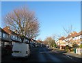
Maytree Walk, Hove
A residential road that links Rowan Avenue to Elm Drive that was built in the 1930s on land belonging to the former parish of Aldrington.
Image: © Simon Carey
Taken: 5 Jan 2017
0.08 miles
7
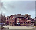
Brighton and Hove Intermediate Care Unit
Image: © PAUL FARMER
Taken: 1 Nov 2022
0.11 miles
8
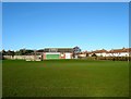
Knoll Recreation Ground, Hove
Built in the 1950s on Hudson's Tip, a former rubbish dump. Access is via footpath from Stapley Road and Rowan Avenue to the north and another that follows the former trackbed of the Dyke Railway from Hove Cemetery to the south. The park includes two junior football pitches, a green belonging to Hangleton Bowls Club immediately beyond the pavilion in view, an enclosed basketball court and a children's playground. The houses on the right face onto Rowan Avenue and were constructed in the 1930s.
Image: © Simon Carey
Taken: 5 Jan 2017
0.12 miles
9
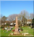
Monument, Hove Cemetery
I neglected to remember who this family monument belongs to but it is located in the north east section of the cemetery near to the footpath. The trees beyond mark the course of the former Dyke Railway which operated from 1887 to 1938 and behind them are houses which front onto Elm Drive.
Hove Cemetery consists of two parts, the original section south of Old Shoreham Road that was first consecrated in 1882 and a second to the north of the road that opened in 1923 as an extension. The northern section is divided further by a public footpath that links the A270 to Elm Drive.
Image: © Simon Carey
Taken: 5 Jan 2017
0.12 miles
10
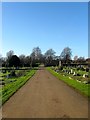
Service Road, Hove Cemetery
The hedge in the distance marks the course of a public footpath that links the Old Shoreham Road to Elm Drive.
Hove Cemetery consists of two parts, the original section south of Old Shoreham Road that was first consecrated in 1882 and a second to the north of the road that opened in 1923 as an extension. The northern section is divided further by a public footpath that links the A270 to Elm Drive.
Image: © Simon Carey
Taken: 5 Jan 2017
0.13 miles