1
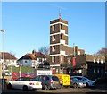
Drill Tower, Hove Fire Station, English Close, Hove
Located on the eastern side of the station whose offices are out of shot to the left. Built around 1963 it occupies the former trackbed of the Dyke Railway which operated from 1887 to 1938.
Image: © Simon Carey
Taken: 5 Jan 2017
0.02 miles
2
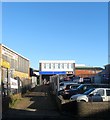
English Close
Small cul-de-sac off Old Shoreham Road filled with business units and Hove Fire Station. Prior to the early 1960s this area was a market garden and nursery.
Image: © Simon Carey
Taken: 7 Jan 2010
0.02 miles
3
Serco, English Close, Hove
Offices of the outsourcing company is tucked away behind
Image well back from the road. The building dates from the 1960s.
Image: © Simon Carey
Taken: 5 Jan 2017
0.03 miles
4
Hove Fire Station
Situated at the northern end of English Close.
Image: © Dave Spicer
Taken: 1 Jan 2013
0.03 miles
5
English Business Park, English Close, Hove
Set of offices built on the site of an old telecommunications depot. English Close was laid out in the 1960s on the site of a former nursery and named after its owner.
Image: © Simon Carey
Taken: 5 Jan 2017
0.03 miles
6
Hove fire station
Hove fire station, English Close, Hove, East Sussex with a Volvo pumping appliance outside.
Image: © Kevin Hale
Taken: 16 Jun 2007
0.04 miles
7
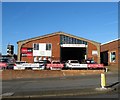
271, Old Shoreham Road, Hove
Currently occupied by wine warehouse, Majestic Wines. If you think the exterior looks suspiciously like a filling station then that is because it once was, see http://regencysociety-jamesgray.com/volume16/source/jg_16_143.html for a view taken in 1969.
Image: © Simon Carey
Taken: 5 Jan 2017
0.04 miles
8
Delphi House, Old Shoreham Road, Hove
Built around 1963 on the site of the former Sackville Nurseries and currently occupied by a Halfords garage and tool hire company. Originally a warehouse the building appears to have been rebuilt at some time, see http://regencysociety-jamesgray.com/volume16/source/jg_16_143.html from 1969.
Image: © Simon Carey
Taken: 5 Jan 2017
0.04 miles
9
269, Old Shoreham Road, Hove
The building was constructed around 1963 and is currently occupied by Pavilion Batteries.
Image: © Simon Carey
Taken: 5 Jan 2017
0.05 miles
10
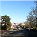
Old Shoreham Road, Hove
A view of the road as it drops into what was once known as Hangleton Bottom with Hove cemetery's southern portion to the right. To the left are a series of commercial premises built on the site of the former Sackville Nurseries. At the top of the further slope is the site of a former bridge that spanned the Dyke Railway that operated between 1887 to 1938. See http://regencysociety-jamesgray.com/volume16/source/jg_16_141.html for a similar view taken in 1969 a few years before the road became a dual carriageway.
Image: © Simon Carey
Taken: 5 Jan 2017
0.05 miles


