IMAGES TAKEN NEAR TO
The Upper Drive, HOVE, BN3 6ND
Introduction
This page details the photographs taken nearby to The Upper Drive, BN3 6ND by members of the Geograph project.
The Geograph project started in 2005 with the aim of publishing, organising and preserving representative images for every square kilometre of Great Britain, Ireland and the Isle of Man.

There are currently over 7.5m images from over14,400 individuals and you can help contribute to the project by visiting https://www.geograph.org.uk
Image Map
Images are licensed for reuse under creativecommons.org/licenses/by-sa/2.0
Notes
- Clicking on the map will re-center to the selected point.
- The higher the marker number, the further away the image location is from the centre of the postcode.
Image Listing (112 Images Found)
Images are licensed for reuse under creativecommons.org/licenses/by-sa/2.0
Image
Details
Distance
1
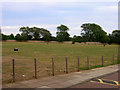
Playing Field, Cardinal Newman School
This one is to the north of the school and contains the rugby pitch and athletics track.
Image: © Simon Carey
Taken: 8 Aug 2006
0.03 miles
2
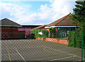
Cardinal Newman Catholic School
Tennis courts and buildings at the back of the school taken behind the flint wall that separates the school from Dyke Road Park.
Image: © Simon Carey
Taken: 27 Aug 2006
0.04 miles
4
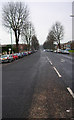
The Upper Drive, Hove
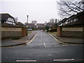
One of the routes out of central Hove The Upper Drive begins at The Drive (B2185) before bisecting the Old Shoreham Road (A270) at an angle before heading up this hill and ending at Dyke Road. Originally an old farm track the road still gives the impression of space as little housing has been built on either side. The buildings on the left form Cardinal Newman RC School and those on the right are a 60s built executive estate. This view was taken from the Dyke Road junction in the top north east corner of the square and looks south west down the hill towards the junction with Old Shoreham Road.
Image: © Simon Carey
Taken: 14 Jan 2006
0.05 miles
5
Greyfriars
Recently built cul de sac not yet marked on the map. It is located off The Upper Drive between Kestrel Close and Cottesmore St Mary's Junior School. This view looks north west from the middle of The Upper Drive.
Image: © Simon Carey
Taken: 25 Mar 2006
0.05 miles
6
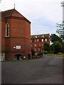
Cardinal Newman Catholic School
Situated on the hilly Upper Drive the school was opened in the early part of the 20th century and is thriving today.
Image: © Simon Carey
Taken: 8 Aug 2006
0.06 miles
7
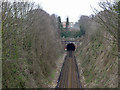
Cliftonville Tunnel, south end
On the Brighton terminus avoiding line connecting Preston Park and Hove. Not easy to photograph - the parapets of the Old Shoreham Road bridge are very high, requiring overhead photography.
Image: © Robin Webster
Taken: 7 Apr 2010
0.08 miles
8
Long Jump, Cardinal Newman School
This is the northern edge of the school playing fields. The railway runs underneath the hill around the far wall whilst the block of flats to the left is Park Lodge. Beyond the far wall is Dyke Road Park.
Image: © Simon Carey
Taken: 21 Oct 2006
0.08 miles
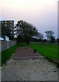
9

Jumpers for Goalposts, Dyke Road Park
Taken from the fence that separates this public park from the private playing fields. The majority of the park is in TQ3005 with the exception of this small sliver. The building to the right is the local Territorial Army centre.
Image: © Simon Carey
Taken: 23 Jul 2006
0.09 miles
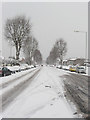
10
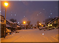
Greyfriars
Recently built cul-de-sac off The Upper Drive, see Image for a view without snow. The snow arrived in Brighton on Thursday night though did not start to settle in earnest until gone 11pm, by this time, 7.25am it was ankle deep and still snowing as can be seen by the flash of the camera reflecting in the falling snow. Snowing finally ceased around 8.30am.
Image: © Simon Carey
Taken: 18 Dec 2009
0.09 miles