IMAGES TAKEN NEAR TO
Elrington Road, HOVE, BN3 6LG
Introduction
This page details the photographs taken nearby to Elrington Road, BN3 6LG by members of the Geograph project.
The Geograph project started in 2005 with the aim of publishing, organising and preserving representative images for every square kilometre of Great Britain, Ireland and the Isle of Man.

There are currently over 7.5m images from over14,400 individuals and you can help contribute to the project by visiting https://www.geograph.org.uk
Image Map (Loading...)


Getting Data...Please wait
Leaflet Map data © OpenStreetMap
Images are licensed for reuse under creativecommons.org/licenses/by-sa/2.0
Notes
- Clicking on the map will re-center to the selected point.
- The higher the marker number, the further away the image location is from the centre of the postcode.
Image Listing (70 Images Found)
Images are licensed for reuse under creativecommons.org/licenses/by-sa/2.0
Image
Details
Distance
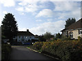
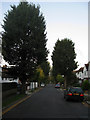
1
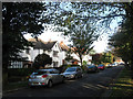
Elrington Road
Residential road linking Hove Park Road and The Droveway that was developed during the 1930s.
Image: © Simon Carey
Taken: 25 Oct 2009
0.02 miles
2
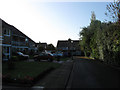
The Paddock
Small cul-de-sac off The Droveway developed in the late 1950s on the site of the former Avenue Tennis Club who amalgamated with the Pavilion Tennis Club and eventually moved back to Image in 1998.
Image: © Simon Carey
Taken: 25 Oct 2009
0.05 miles
3
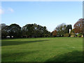
Playing Field, Mowden School
Small playing squeezed between a public footpath that links Kelly Road to The Droveway and Elrington Road which lies beyond the trees on the far side.
Image: © Simon Carey
Taken: 25 Oct 2009
0.05 miles
4
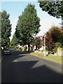
Hove Park Road
Residential road linking Goldstone Crescent with Dyke Road. Looking towards the junction with Elrington Road.
Image: © Simon Carey
Taken: 25 Oct 2009
0.06 miles
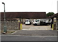
5
Entrance to Pavilion & Avenue Tennis Club
Opposite view of Image
Image: © Simon Carey
Taken: 25 Oct 2009
0.06 miles
6
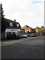
Tesco Express, The Droveway
One of many that have sprung up in the last decade.
Image: © Simon Carey
Taken: 25 Oct 2009
0.06 miles
7
Dairy, Droveway, Hove
The dairy now belongs to Dairy Crest, but was in the hands of Unigate from the 1960's to the 90's.
Image: © nick macneill
Taken: 15 Jul 2011
0.07 miles
8
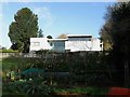
Atelier, The Droveway
Rear view of a modern building built next to the footpath between Kelly Road and The Droveway and fronting onto the latter. A small allotment lies in the foreground separating the footpath from a playing field owned by Mowden School.
Image: © Simon Carey
Taken: 25 Oct 2009
0.08 miles
9
Hove Park Road
Residential street that links Dyke Road with Goldstone Crescent that was developed from 1928 onwards. This section is between Rigden Road and Shirley Drive.
Image: © Simon Carey
Taken: 25 Oct 2009
0.08 miles
10
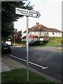
Entrance to Pavilion & Avenue Tennis Club
Heading off The Droveway between Mowden School and Elrington Road.
Image: © Simon Carey
Taken: 25 Oct 2009
0.08 miles