IMAGES TAKEN NEAR TO
Hogarth Road, HOVE, BN3 5RG
Introduction
This page details the photographs taken nearby to Hogarth Road, BN3 5RG by members of the Geograph project.
The Geograph project started in 2005 with the aim of publishing, organising and preserving representative images for every square kilometre of Great Britain, Ireland and the Isle of Man.

There are currently over 7.5m images from over14,400 individuals and you can help contribute to the project by visiting https://www.geograph.org.uk
Image Map
Images are licensed for reuse under creativecommons.org/licenses/by-sa/2.0
Notes
- Clicking on the map will re-center to the selected point.
- The higher the marker number, the further away the image location is from the centre of the postcode.
Image Listing (108 Images Found)
Images are licensed for reuse under creativecommons.org/licenses/by-sa/2.0
Image
Details
Distance
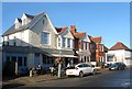
1
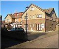
Charles Lodge, New Church Road, Aldrington, Hove
Although it is addressed as New Church Road the building is located at the end a small track called St Philips Mews which it predates. Built in the 1920s as Southcot it later became Grenville Lodge. It is now Charles Lodge, a residential care home.
Image: © Simon Carey
Taken: 11 Dec 2016
0.04 miles
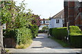
2
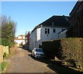
St Philips Mews, Aldrington, Hove
An unmade track off New Church Road that leads to Image, the western entrance of Image and three houses beyond the latter which were constructed in 1996. These dwellings meant the track required a name and was thus christened St Philips Mews after the church, part of which is visible on the right. This explains the anomaly of Charles Lodge (out of shot to the left) which was built in the 1920s and is officially number 75 New Church Road. The track itself was for many years known locally as Naismith Lane.
Image: © Simon Carey
Taken: 11 Dec 2016
0.05 miles
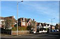
4
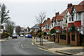
Amesbury Crescent
Beyond a crossroads the road continues down to the seafront as Berriedale Avenue.
Image: © Robin Webster
Taken: 23 Mar 2010
0.07 miles
5
12-26, Richardson Road, Aldrington, Hove
Number 12-16 is the Drury Tea and Coffee shop who moved here in 2006 from Edward Street where it had been operating since the 1960s. The firm itself has been in existence since 1935 and besides running their cafe also sell tea and coffee wholesale along with machines for making them. Number 20 is a small deli, number 24 a private house which has a statue of Buddha in the front garden (Not visible here), whilst 26 is a small service garage. For other shops on this road see, Image and Image
Image: © Simon Carey
Taken: 11 Dec 2016
0.07 miles
6
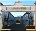
Lion Mews, Aldrington, Hove
Located between Richardson Road and St Philips Mews. Built in 1881 as stables for the Duke of Portland and now containing a number of small business units on the ground floor with flats occupying the former hay lofts.
Image: © Simon Carey
Taken: 11 Dec 2016
0.07 miles
7
85-95, New Church Road, Aldrington, Hove
The block is located between Hogarth Road and Amesbury Crescent and was once the southern extremity of Wish Brick Field which provided building materials for much of the suburb. Consequently, once exhausted the field itself was developed in the 1930s.
Image: © Simon Carey
Taken: 14 Dec 2016
0.07 miles
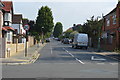
9
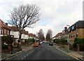
Hogarth Road, Aldrington, Hove
A residential road that links New Church Road, the B2066, and Portland Road. Largely built in the 1930s with the exception of Everest House on the right which was built sometime in the last thirty years on a previously undeveloped plot of land.
Image: © Simon Carey
Taken: 14 Jan 2017
0.08 miles
10
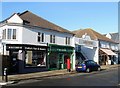
2-10, Richardson Road, Aldrington, Hove
These shops were built as part of Image in 1881. Located to the south of the entrance is number 2 a beauty salon and number 4 currently a florist but for many years a former Post Office. To the north is number 8 an off licence and number 10 is a specialist watch repair shop.
Image: © Simon Carey
Taken: 11 Dec 2016
0.08 miles