IMAGES TAKEN NEAR TO
Ingram Crescent West, HOVE, BN3 5NX
Introduction
This page details the photographs taken nearby to Ingram Crescent West, BN3 5NX by members of the Geograph project.
The Geograph project started in 2005 with the aim of publishing, organising and preserving representative images for every square kilometre of Great Britain, Ireland and the Isle of Man.

There are currently over 7.5m images from over14,400 individuals and you can help contribute to the project by visiting https://www.geograph.org.uk
Image Map (Loading...)


Getting Data...Please wait
Leaflet Map data © OpenStreetMap
Images are licensed for reuse under creativecommons.org/licenses/by-sa/2.0
Notes
- Clicking on the map will re-center to the selected point.
- The higher the marker number, the further away the image location is from the centre of the postcode.
Image Listing (68 Images Found)
Images are licensed for reuse under creativecommons.org/licenses/by-sa/2.0
Image
Details
Distance
1
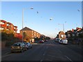
Portland Road, Hove
One of four east-west roads that run parallel to each other through the old parish of Aldrington, the others being Kingsway (A259), New Church Road (B2066) and Old Shoreham Road (A270). The road was laid out in the 1870s and developed gradually over the next forty or so years.
Image: © Simon Carey
Taken: 3 Dec 2016
0.09 miles
2
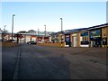
Portland Business Park, Portland Road, Hove
Originally an open field called South Gores, according to Aldrington's 1840 tithe map, that had become allotments by the time of the 1898 OS map and remained so until 1921 when the section adjacent to Olive road was acquired by the Brighton Equitable Co-Operative Society who initially built a bakery fronting onto Portland Road and later included buildings erected for their grocery, dairy and laundry departments. The site was vacated in the mid 1990s and the current trading estate built soon after.
See http://regencysociety-jamesgray.com/volume16/source/jg_16_054.html
Image: © Simon Carey
Taken: 3 Dec 2016
0.12 miles
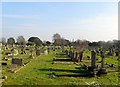
3
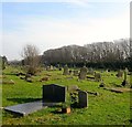
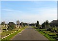
Hove Cemetery
The south western section which was not consecrated until 1912 despite being purchased at the same time as the rest which opened in 1882. For three decades it was used as a hay field. Beyond the trees to the south is the railway line.
Hove Cemetery consists of two parts, the original section south of Old Shoreham Road that was first consecrated in 1882 and a second to the north of the road that opened in 1923 as an extension
Image: © Simon Carey
Taken: 22 Jan 2017
0.12 miles
4
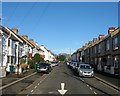
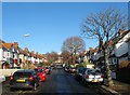
Bolsover Road, Aldrington, Hove
A residential road that links Portland Road to Kingsthorpe Road that had was developed before 1914.
Image: © Simon Carey
Taken: 14 Dec 2016
0.13 miles
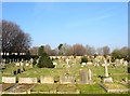
5
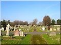
Main Avenue, Hove Cemetery
Providing access from the far eastern to far western sides through the arch of the distant Image This part is in the western section of the cemetery which was not consecrated until 1912 despite being purchased at the same time as the rest which opened in 1882.
Hove Cemetery consists of two parts, the original section south of Old Shoreham Road that was first consecrated in 1882 and a second to the north of the road that opened in 1923 as an extension
Image: © Simon Carey
Taken: 22 Jan 2017
0.13 miles
6
Woodhouse Road, Aldrington, Hove
A residential road that links Portland Avenue to Portland Road. Originally a field called Little Golhards that was located in a detached portion of Portslade parish that was acquired by Aldrington in 1883 by which point it was being used a brick field. Development occurred in the early 1930s with part of the road completed by the time of the 1932 OS map.
Image: © Simon Carey
Taken: 14 Dec 2016
0.13 miles
7
Hove Cemetery
An unmade path on the western side. The western section wasn't consecrated until 1912 despite being purchased at the same time as the rest which opened in 1882. For the intervening thirty years it was used as a hay field.
Hove Cemetery consists of two parts, the original section south of Old Shoreham Road that was first consecrated in 1882 and a second to the north of the road that opened in 1923 as an extension
Image: © Simon Carey
Taken: 22 Jan 2017
0.14 miles
8
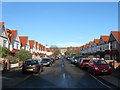
Mansfield Road, Aldrington, Hove
A residential road that links Portland Avenue to Portland Road. Originally part of a field called Great Golhards which was located within a detached portion of Portslade parish that was acquired by Aldrington in 1883 by which point part was used as a brick field. The road was laid out and developed in the early 1930s.
Image: © Simon Carey
Taken: 14 Dec 2016
0.14 miles
9
Hove Cemetery
The western side of the southern section which was not consecrated until 1912 despite being purchased at the same time as the rest in 1882. For three decades it was used as a hay field. The line of trees in the distance mark the location of the original western boundary of the cemetery.
Hove Cemetery consists of two parts, the original section south of Old Shoreham Road that was first consecrated in 1882 and a second to the north of the road that opened in 1923 as an extension
Image: © Simon Carey
Taken: 22 Jan 2017
0.14 miles
10
Hove Cemetery
The north western end of the cemetery that wasn't consecrated until 1912 although it was purchased at the same time as the rest in 1882. For three decades it was used as a hay field. The flint wall in the distance marks the location of old Shoreham Road beyond which is the northern part.
Hove Cemetery consists of two parts, the original section south of Old Shoreham Road that was first consecrated in 1882 and a second to the north of the road that opened in 1923 as an extension
Image: © Simon Carey
Taken: 22 Jan 2017
0.15 miles