IMAGES TAKEN NEAR TO
Arthur Street, HOVE, BN3 5EY
Introduction
This page details the photographs taken nearby to Arthur Street, BN3 5EY by members of the Geograph project.
The Geograph project started in 2005 with the aim of publishing, organising and preserving representative images for every square kilometre of Great Britain, Ireland and the Isle of Man.

There are currently over 7.5m images from over14,400 individuals and you can help contribute to the project by visiting https://www.geograph.org.uk
Image Map
Images are licensed for reuse under creativecommons.org/licenses/by-sa/2.0
Notes
- Clicking on the map will re-center to the selected point.
- The higher the marker number, the further away the image location is from the centre of the postcode.
Image Listing (136 Images Found)
Images are licensed for reuse under creativecommons.org/licenses/by-sa/2.0
Image
Details
Distance
1
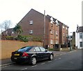
Tintagel Court, Arthur Street, Aldrington, Hove
When the street was built in the 1890s this corner was occupied by a laundry which continued in operation until the early 1960s when it became a depot. At some point the buildings were demolished and replaced with these flats. See http://regencysociety-jamesgray.com/volume16/source/jg_16_008.html for the original laundry and http://regencysociety-jamesgray.com/volume16/source/jg_16_009.html for the depot.
Image: © Simon Carey
Taken: 17 Dec 2016
0.01 miles
2
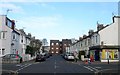
Westbourne Street, Aldrington, Hove
The northern end of the street that runs between Westbourne Gardens and Arthur Street that was developed in the early 1890s. The flats at the end of the street are Image
Image: © Simon Carey
Taken: 17 Dec 2016
0.03 miles
3
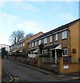
Pendragon Court, Arthur Street, Aldrington, Hove
Originally the site of a laundry that survived until the 1970s when both they are some housing were demolished to eventually make way for a mixed development of houses and flats. See http://regencysociety-jamesgray.com/volume16/source/jg_16_012.html and http://regencysociety-jamesgray.com/volume16/source/jg_16_013.html for a view of the old houses.
Image: © Simon Carey
Taken: 17 Dec 2016
0.03 miles
4
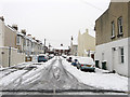
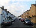
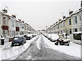
Sheridan Terrace
Residential street that runs like a crescent starting and finishing on Coleridge Street. Part of the Poets Corner district named after the roads than any bohemian lifestyle that was developed during the 1890s.
Image: © Simon Carey
Taken: 2 Dec 2010
0.03 miles
5
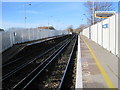
Aldrington railway station, West Sussex
Opened in 1905 on the London Brighton & South Coast Railway's line from Brighton to Shoreham-by-Sea. View west towards Portslade and Shoreham.
Image: © Nigel Thompson
Taken: 25 Nov 2011
0.05 miles
6

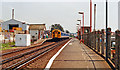
Aldrington Station
Opened in 1905 as Dyke Junction Halt to serve as an interchange for the Dyke branch railway. It was renamed Aldrington Halt in 1932 and eventually became just Aldrington. Staffing went in 1990 and a couple of small shelters are the only facilities available here though it is served by 4 trains in each direction per hour during the day and can be busy in peak periods. The buildings from St Joseph's trading estate are on the left.
Image: © Simon Carey
Taken: 14 Jan 2009
0.05 miles
7
Aldrington station, 1990
View eastward, towards Hove and Brighton: ex-LB&SCR Brighton - Littlehampton/Portsmouth main line. The station was 'Dyke Junction' until 6/32, Aldrington 'Halt' until 5/69.
Image: © Ben Brooksbank
Taken: 12 Jul 1990
0.06 miles
8
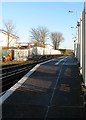
Aldrington Station
Opened in 1904 as Dyke Junction Halt the station was renamed and rebuilt in 1932. Access is via footpaths on either side down to a footpath that links Tamworth Road to Amherst Crescent.
Image: © Simon Carey
Taken: 5 Jan 2017
0.06 miles
9
Arthur Street, Aldrington, Hove
A residential street that runs west from Westbourne Street becoming Mortimer Road at the junction with Rutland Road. The road was developed from the mid 1890s and completed by the turn of the centuries. On the right are the buildings of Image Much of the northern side was removed in the 1970s.
Image: © Simon Carey
Taken: 17 Dec 2016
0.06 miles
10
Shakespeare Street
Running between the ends of Sheridan Terrace. The area is part of Poets Corner named after the roads rather than any bohemian lifestyle and was developed during the 1890s.
Image: © Simon Carey
Taken: 2 Dec 2010
0.07 miles