IMAGES TAKEN NEAR TO
St. Leonards Road, HOVE, BN3 4QR
Introduction
This page details the photographs taken nearby to St. Leonards Road, BN3 4QR by members of the Geograph project.
The Geograph project started in 2005 with the aim of publishing, organising and preserving representative images for every square kilometre of Great Britain, Ireland and the Isle of Man.

There are currently over 7.5m images from over14,400 individuals and you can help contribute to the project by visiting https://www.geograph.org.uk
Image Map (Loading...)


Getting Data...Please wait
Leaflet Map data © OpenStreetMap
Images are licensed for reuse under creativecommons.org/licenses/by-sa/2.0
Notes
- Clicking on the map will re-center to the selected point.
- The higher the marker number, the further away the image location is from the centre of the postcode.
Image Listing (166 Images Found)
Images are licensed for reuse under creativecommons.org/licenses/by-sa/2.0
Image
Details
Distance
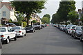
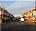
3
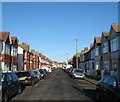
St Leonard's Road, Aldrington, Hove
A residential road that links Kingsway, the A259, to New Church Road, the B2066, that was begun in the late 1880s though not completed on the eastern side until the first decade of the 20th century.
Image: © Simon Carey
Taken: 22 Dec 2016
0.02 miles
4
Seaford Road, Aldrington, Hove
A residential road that links St Leonard's Road to Boundary Road/Station Road, the B2194. The northern side was developed in the 1890s whilst the southern side was not completed until the first decade of the 20th century.
Image: © Simon Carey
Taken: 22 Dec 2016
0.03 miles
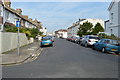
5
St Leonard's Avenue, Aldrington, Hove
A residential road linking Kingsway, the A259, to St Leonard's Road that was developed in the first decade of the 20th century and completed by the start of World War One. See Image for the northern section.
Image: © Simon Carey
Taken: 22 Dec 2016
0.05 miles
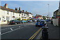
8
The Blue Anchor, Station Road
Local pub in Portslade's main shopping area.
Image: © Peter Holmes
Taken: 17 Mar 2012
0.05 miles
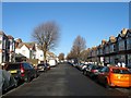
9
St Leonard's Avenue, Aldrington
Road laid out in the late 19th century which eventually filled in the vacant land between Portslade and Hove. Aldrington had been a parish in its own right but had been deserted from the middle ages and by the beginning of the 19th century consisted of a ruined church and a population of 3, the family of the local tollgate keeper.
Image: © Simon Carey
Taken: 14 Jan 2009
0.06 miles
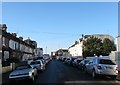
10
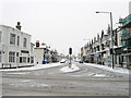
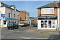
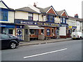
Station Road/Boundary Road
The B2194 is single road with two names, the houses on the left are Station Road, those on the right Boundary Road. In the early 19th century the road was known as Aldrington Drove or Red House Droveway and marked the parish boundary between Portslade and Hove. The coming of the railway and the construction of Portslade station meant the route's name was changed to Station Road which remained the case until 1895 when a dispute between the two councils over who was responsible for the upkeep resulted in a change which drew the boundary down the centre of the road and split responsibility in half. The eastern side's name was changed to Boundary Road in 1903 to avoid confusion regarding stations as Station Road, Hove did not lead to Hove station though Station Road, Portslade did lead to Portslade station. This state of affairs remains the same today throughout the entire length between the A259 and the A270 though north of Portslade station the western half becomes Carlton Terrace.
The road today is the main shopping street for Portslade though this was developed only from the 1930s onwards as the original road was built with upmarket Victorian villas and began life as a purely residential district. The building on the corner was the Halfway House a pub that was built before the growth of the residential area around it being named after its position between Brighton and Shoreham. Unfortunately it closed a couple of years ago and has now been converted into offices.
Image: © Simon Carey
Taken: 2 Dec 2010
0.06 miles