IMAGES TAKEN NEAR TO
Livingstone Road, HOVE, BN3 3WP
Introduction
This page details the photographs taken nearby to Livingstone Road, BN3 3WP by members of the Geograph project.
The Geograph project started in 2005 with the aim of publishing, organising and preserving representative images for every square kilometre of Great Britain, Ireland and the Isle of Man.

There are currently over 7.5m images from over14,400 individuals and you can help contribute to the project by visiting https://www.geograph.org.uk
Image Map
Images are licensed for reuse under creativecommons.org/licenses/by-sa/2.0
Notes
- Clicking on the map will re-center to the selected point.
- The higher the marker number, the further away the image location is from the centre of the postcode.
Image Listing (189 Images Found)
Images are licensed for reuse under creativecommons.org/licenses/by-sa/2.0
Image
Details
Distance
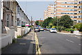
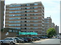
3
Flats in Clarendon Road, Hove
Near to Hove Station
Image: © Paul Gillett
Taken: 7 Feb 2014
0.03 miles
4
Flats on Clarendon Road, Hove
To see the other side of these flats, click here Image
Image: © Danny P Robinson
Taken: 31 May 2007
0.03 miles
5
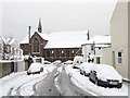
St Barnabas Church
Located on the corner of Sackville Road and Coleridge Street though this view is from Sheridan Terrace. It was consecrated in 1883 to serve the growing area around Conway Street and the soon to be built Poets Corner. Prior to the church being built the land was allotments and before that a field which was a popular stopping place for gypsies.
Image: © Simon Carey
Taken: 2 Dec 2010
0.04 miles
6
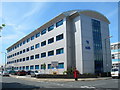
The Agora, Hove
Offices to let on the corner of Fonthill Road and Ellen Street.
Image: © Danny P Robinson
Taken: 31 May 2007
0.04 miles
7
Flats on Ellen Street, Hove
To see the other side of these flats, click here Image
Image: © Danny P Robinson
Taken: 31 May 2007
0.04 miles
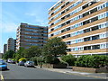
8
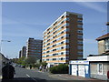
Clarendon Road, Hove
Blocks of flats on Clarendon Road, Hove.
Image: © Malc McDonald
Taken: 10 Apr 2011
0.05 miles
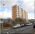
9
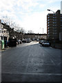
Ethel Street
Linking Conway Street with Clarendon Road. Much of the former slum houses were cleared in the 1960s and replaced with high rise blocks, one of which, Livingstone House, can be seen on the right.
Image: © Simon Carey
Taken: 14 Jan 2009
0.05 miles
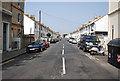
10
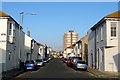
Goldstone Street, Hove
A residential street that links Clarendon Villas to Clarendon Road though originally continued northwards to the railway bridge until redevelopment in the late 1960s. The street was built in the late 1870s-/early 1880s. The tower block is Goldstone House.
Image: © Simon Carey
Taken: 17 Dec 2016
0.05 miles