IMAGES TAKEN NEAR TO
The Drive, HOVE, BN3 3PD
Introduction
This page details the photographs taken nearby to The Drive, BN3 3PD by members of the Geograph project.
The Geograph project started in 2005 with the aim of publishing, organising and preserving representative images for every square kilometre of Great Britain, Ireland and the Isle of Man.

There are currently over 7.5m images from over14,400 individuals and you can help contribute to the project by visiting https://www.geograph.org.uk
Image Map
Images are licensed for reuse under creativecommons.org/licenses/by-sa/2.0
Notes
- Clicking on the map will re-center to the selected point.
- The higher the marker number, the further away the image location is from the centre of the postcode.
Image Listing (239 Images Found)
Images are licensed for reuse under creativecommons.org/licenses/by-sa/2.0
Image
Details
Distance
1
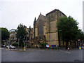
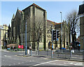
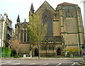
All Saints' Church, Hove, East Sussex
All Saints' Church is on the corner of The Drive and Eaton Road.
Image: © Christine Matthews
Taken: 11 Jul 2009
0.02 miles
2
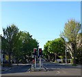
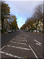
The Drive, Hove
The B2185 heading north from the junction with Eaton Road.
Image: © Simon Carey
Taken: 8 May 2020
0.02 miles
3
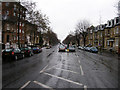
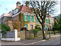
Wilbury Road
This part of Hove was built up from the 1870s onwards when the Stanford Estate was given over to commercial development. This minor road heads south to the sea and gives some idea to space afforded to the roads and avenues for the well to do, consequently unlike many other Victorian roads this one is wide enough to have room for cars to park in the middle. The original buildings are by and large untouched with the exception of a few blocks of flats on the eastern side. This view looks south from the curve in the road near the junction with the B2120.
Image: © Simon Carey
Taken: 19 Feb 2006
0.03 miles
4
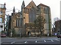
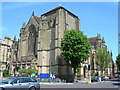
All Saints Church, Hove
All Saints is an imposing church—one of the largest of the 19th century Gothic revival—and bears some resemblance to one of John Loughborough Pearson's largest ecclesiastical projects, Truro Cathedral, building of the church started in 1889. It has served as the parish church for the whole of Hove since 1892 http://www.allsaintshove.org/
Image: © Paul Gillett
Taken: 5 Dec 2010
0.04 miles
5
Hove: All Saints
An elephantine Victorian church on Eaton Road.
Image: © John Sutton
Taken: 10 Apr 2022
0.04 miles
6
The Drive
The B2186 which links Kingsway and Old Shoreham Road. Laid out when the Stanford estate was developed in the 1870s hence the straightness of the road. This part lies between Eaton Road and Cromwell Road.
Image: © Simon Carey
Taken: 26 Nov 2006
0.05 miles
7
Wilbury Lawn, Wilbury Road
Built in 1907 in the style of a French Chateau. Today the house has been extended and subdivided into flats. The south west floodlights of Sussex's County Ground can be seen in the background.
Image: © Simon Carey
Taken: 7 May 2006
0.05 miles
8
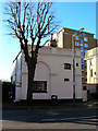
The Coach House, Eaton Road
Same style building as those that provide the entrance to Wilbury Grove.
Image: © Simon Carey
Taken: 3 Mar 2007
0.06 miles
9
All Saints Church
On the corner of Eaton Road and The Drive. Built in 1890 by J.L Pearson it is now the parish church of Hove.
Image: © Simon Carey
Taken: 26 Nov 2006
0.06 miles
10
All Saints Church, Hove
Taken from the other side of The Drive and Blatchington Road (and therefore, from the adjacent grid square)
Image: © Danny P Robinson
Taken: 31 May 2007
0.06 miles