IMAGES TAKEN NEAR TO
Medina Villas, HOVE, BN3 2RP
Introduction
This page details the photographs taken nearby to Medina Villas, BN3 2RP by members of the Geograph project.
The Geograph project started in 2005 with the aim of publishing, organising and preserving representative images for every square kilometre of Great Britain, Ireland and the Isle of Man.

There are currently over 7.5m images from over14,400 individuals and you can help contribute to the project by visiting https://www.geograph.org.uk
Image Map
Images are licensed for reuse under creativecommons.org/licenses/by-sa/2.0
Notes
- Clicking on the map will re-center to the selected point.
- The higher the marker number, the further away the image location is from the centre of the postcode.
Image Listing (385 Images Found)
Images are licensed for reuse under creativecommons.org/licenses/by-sa/2.0
Image
Details
Distance
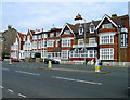
1
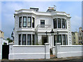
Leicester Lodge, Hove Place
On the corner of Hove Place and Medina Villas is this late Victorian house now subdivided into flats.
Image: © Simon Carey
Taken: 1 Jun 2007
0.03 miles
2
The Priory, St Catherine's Terrace, Hove
Located on the corner of Medina Villas and built in the early 1960s on the site of a former house that was also known locally as The Priory that had been built in 1864, see http://regencysociety-jamesgray.com/volume12/source/jg_12_027.html for a view from 1958 taken prior to demolition.
Image: © Simon Carey
Taken: 14 Jan 2017
0.04 miles
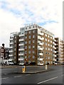
4
Albany Towers, St Catherine's Terrace, Hove
Located on the corner of Albany Villas and built in the 1970s on the site of two large 19th century houses, see http://regencysociety-jamesgray.com/volume12/source/jg_12_060.html for a shot taken in 1912.
Image: © Simon Carey
Taken: 14 Jan 2017
0.04 miles
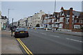
5
St Catherine's Lodge Hotel, Kingsway
Closed as a hotel in 2001 and run as a homeless hostel ever since though that too is coming to an end as the local council have recently refused to extend the licence. Will probably end up being converted intoo flats. Kingsway is the main A259 Brighton to Shoreham road.
Image: © Simon Carey
Taken: 1 Jun 2007
0.05 miles
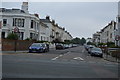
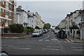
6
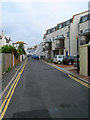
Hove Place, Hove
A residential street that links Osborne Villas to Medina Villas that was built in the 1850s. On the right hand side are the rear views of Image and Image
Image: © Simon Carey
Taken: 18 Feb 2017
0.05 miles
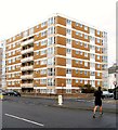
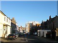
9
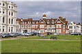
St Catherine's Lodge
Looking across Medina Lawn to St Catherine's Lodge on St Catherine's Terrace, Kingsway, with Albemarle Mansions on the far left. St Catherine's Lodge was built in the 1850s and became a hotel, St Catherine's Lodge Hotel, in 1927. For a period in the early 2000s it served as a hostel for homeless people. It remains a hostel offering cheap accommodation (but with wider availability) and has been renamed Smart Sea View Brighton (despite being in Hove). Medina Lawn was originally a private lawn for residents of the terrace but was taken over by Hove Council after the Second World War for public use.
Image: © Ian Capper
Taken: 21 Jan 2022
0.05 miles
10
Medina Place
Small backstreet running between Hove Place and Osborne Villas. The older buildings are in the middle with newer small scale terracing to the north and Parnell Flats to the immediate right. The latter are named after Charles Stewart Prnell who lived in nearby Medina Terrace.
Image: © Simon Carey
Taken: 1 Jun 2007
0.05 miles