1
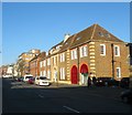
Hove old fire station, Hove Street
Hove old fire station, Hove Street, Hove, East Sussex
Image: © Kevin Hale
Taken: 9 Nov 2009
0.01 miles
2
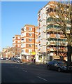
The Connaught Pub, Hove
In Hove Street
Image: © Paul Gillett
Taken: 14 Nov 2012
0.01 miles
3
Audley House/Regent House/Vallance House, Hove Street, Hove
Three buildings located between
Image to the south and Vallance Road to the north that were built around 1926. Audley House to the left was a purpose built fire station that replaced former premises in George Street and remained in operation until 1976 when it moved to its current site in English Close, see http://regencysociety-jamesgray.com/volume12/source/jg_12_177.html for a view of the station in 1928. The building was converted into flats in 1981. Regent House in the middle was originally an electricity sub-station and is now combined offices and flats. Vallance House at the northern end to the left was originally a sorting office for the Royal Mail but has been converted into offices occupied by a solicitors practice since 2006. Previously the site had been part of a farm, see http://regencysociety-jamesgray.com/volume12/source/jg_12_157.html for a view from the north taken in 1914.
Image: © Simon Carey
Taken: 18 Feb 2017
0.02 miles
4
Dolphin Court, Hove Street, Hove
Located on the corner of Vallance Road and built in the 1960s on what was empty land.
Image: © Simon Carey
Taken: 18 Feb 2017
0.03 miles
5
Vallance Gardens
Residential street that runs between Vallance Road and Kingsway, the A259. Not much activity after 8-10 inches of snow fell overnight.
Image: © Simon Carey
Taken: 2 Dec 2010
0.04 miles
6
A2023
Image: © N Chadwick
Taken: 4 Jul 2015
0.04 miles
7
The Connaught, Hove Street
Erected in 1880 to serve the new estates being developed in the area.
Image: © Simon Carey
Taken: 1 Jan 2007
0.04 miles
8
Vallance Court
Small area of flats to the rear of Hove Street built on the site of the former manor house.
Image: © Simon Carey
Taken: 2 Dec 2010
0.05 miles
9
Hove Manor, Hove Street, Hove
Block of flats built in the 1930s on the site of the former Hove Manor that had been constructed in 1786 and demolished in 1933. See http://regencysociety-jamesgray.com/volume12/source/jg_12_153.html for a view taken in 1915, and http://regencysociety-jamesgray.com/volume12/source/jg_12_173.html for a view of the flats nearing completion in 1936.
Hove Street itself had been the old village street heading north from the beach to the Downs and had originally been narrow and possessing a bend. This disappeared in the 1920s when the street was widened and developed. In the process all the old 18th and 19th century buildings were demolished, the last going in the 1980s.
Image: © Simon Carey
Taken: 18 Feb 2017
0.05 miles
10
A2023/B2066 Crossroads, Hove
Where the A2023 (north-south) meets the B2066 (east-west). Clockwise; Sackville Road heads north, Church Road east, Hove Street south and New Church Road west. This point also marks the western most edge of Hove's shopping area.
Image: © Simon Carey
Taken: 1 Jan 2007
0.06 miles


