IMAGES TAKEN NEAR TO
Sussex Street, BRIGHTON, BN2 9HS
Introduction
This page details the photographs taken nearby to Sussex Street, BN2 9HS by members of the Geograph project.
The Geograph project started in 2005 with the aim of publishing, organising and preserving representative images for every square kilometre of Great Britain, Ireland and the Isle of Man.

There are currently over 7.5m images from over14,400 individuals and you can help contribute to the project by visiting https://www.geograph.org.uk
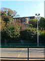
Image Map
Images are licensed for reuse under creativecommons.org/licenses/by-sa/2.0
Notes
- Clicking on the map will re-center to the selected point.
- The higher the marker number, the further away the image location is from the centre of the postcode.
Image Listing (454 Images Found)
Images are licensed for reuse under creativecommons.org/licenses/by-sa/2.0
Image
Details
Distance
1
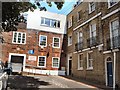
Resource Centre & Unemployment Centre
Services for the community in Carlton Hill, Brighton
See http://www.resourcecentre.org.uk/ for details about the resource centre
See http://www.bucfp.org/index.htm for details about the unemployed centre
Image: © Paul Gillett
Taken: 18 Jun 2011
0.04 miles
2
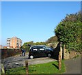
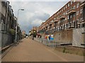
Sussex Street, Brighton
One of the east-west roads that ran up the hill from Grand Parade to Queen's Park Road. The western part of the street at the foot of the hill is now Image with Sussex Street now beginning from the junction with John Street. On the right is coastal Counties House whilst further up and just visible are the council houses built as part of the Tarner Estate in 1934. For a similar view in 1959 see http://regencysociety-jamesgray.com/volume27/source/jg_27_051.html
Image: © Simon Carey
Taken: 25 Oct 2015
0.04 miles
3
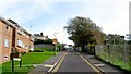
Elmore Road
Opposite the entrance to the recreation ground is the junction of Sussex Street and Elmore Road. This road and the one parallel in Tarner Road were developed on vacant land owned by the Tarner estate from 1931.
Click on the link to take you to the next page. http://www.geograph.org.uk/photo/231695
Image: © Simon Carey
Taken: 1 Sep 2006
0.04 miles
4
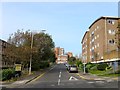
John Street, Brighton
The current road heads north from Edward Street and eventually ends on Albion Hill. However, it originally terminated at Carlton Hill with this section in view once known as Nelson Street until the old Victorian slum housing was cleared in the late 1930s though little was developed along the road until the 1960s. The road name appears to have changed in the 1970s. The building on the right is The Curve whilst in the distance is the former Lion & Unicorn pub that closed around 2010 and has now been converted into flats.
Image: © Simon Carey
Taken: 4 Oct 2015
0.04 miles
5
Site of Apollo Terrace, Brighton
Originally a narrow terrace that stretched from Sussex Street to Richmond Street that were built in the 1810s. Condemned as slum housing part of was removed in 1930s, more in 1946 after a landslide, and the final properties demolished in the early 1950s. See http://regencysociety-jamesgray.com/volume27/source/jg_27_041.html for a 1935 view. The car park occupies the southern end of the former terrace whilst the rest has been left to nature. The chimneys on the left belong to Image which were built between 1905-09 within a former chalk pit. Richmond Heights is the large block in the distance.
Image: © Simon Carey
Taken: 1 Nov 2015
0.04 miles
6
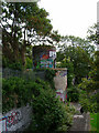
Tarner's Tower, Sussex Street
Head east back up Carlton Hill then north along St John's Place and a little west down Sussex Street. The recreation ground here is in the former garden of St John's Lodge in Tilbury Place. The tower was built by Tarner, a wealthy businessman, in the mid 19th century to look out over the Channel to view his ships coming back to the country. The grounds were given to the corporation by Tarner's descendants and unfortunately although it is listed the tower is looking a little sorry for itself at the moment.
Click on the link to take you to the next page. http://www.geograph.org.uk/photo/231689
Image: © Simon Carey
Taken: 1 Sep 2006
0.04 miles
7
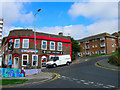
Lion and Unicorn, Sussex Street
Head south along John Street until the junction of Sussex Street is reached just north of the pub. Although rebuilt the pub remains in the same position it occupied before the slum clearances and is one of the few buildings in this area to retain its position. The steep gradient in this part of town is evident in Sussex Street.
Click on the link to take you to the next page. http://www.geograph.org.uk/photo/231626
Image: © Simon Carey
Taken: 1 Sep 2006
0.04 miles
8
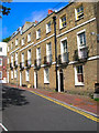
Tilbury Place
Head south down John Street then east up Carlton Hill and north into Tilbury Place.Number 1 was developed as St Johns Lodge in 1810 and the rest of the row followed in 1812 and initially called Patriot Place but renamed Tilbury in 1862 after Edwin Tarner's wife's maiden name. The northern end is closed off by Prior House constructed in 1936 and just visible and the western side provides the entrance to Carlton Hill Primary School. The row was given to Brighton Corporation in 1933 and number 1 became known as Tarner House.
Click on the link to take you to the next page. http://www.geograph.org.uk/photo/231643
Image: © Simon Carey
Taken: 1 Sep 2006
0.05 miles
9
Tarner Tower, Tarner Recreation Ground, Brighton
A folly built in the 1800s in the extensive gardens of St John's Lodge owned by Edward Tilbury whose daughter married a merchant Edwin Tarner who was supposed to use the tower as a lookout for his ships in the Channel so he could travel to London and meet them. The Tarner family gave up the house and gardens in the 1930s and the latter were acquired by the council who turned them into a recreation ground in 1934. Beyond the tower is Tarnerland Nursery built in the upper level of the former gardens.
Image: © Simon Carey
Taken: 1 Nov 2015
0.05 miles
10
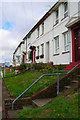
Nelson Row, Brighton
Flats built in 1930's
Image: © Paul Gillett
Taken: 11 Jun 2011
0.06 miles