1
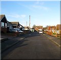
Glynde Avenue, Saltdean
A residential road that runs between Greenbank Avenue and Saltdean Vale that was developed in the 1950s. Some early morning frost still remains on the road and somebody has made use of the grit in the bunker on the left.
Image: © Simon Carey
Taken: 16 Jan 2016
0.03 miles
2
Mount Drive, Saltdean
A residential road that links Greenbank Avenue to Saltdean Vale. The northern side appears to have been developed by 1951 with the southern side added later that decade. Originally known as Saltdean Drive but renamed by the 1960s.
Image: © Simon Carey
Taken: 16 Jan 2016
0.05 miles
3
Greenbank Avenue, Saltdean
A residential road that runs from Chichester Drive East to Hempstead Road. It was laid out in the 1920s and originally called Quarry Avenue after the nearby pit which supplied the chalk that formed the surfaces of the early roads. Development was completed north of Mount Drive by the outbreak of World War Two with the southern section completed during the 1950s during which it acquired its current name.
Image: © Simon Carey
Taken: 28 Jan 2016
0.06 miles
4
Chiltington Way, Saltdean
A residential road that runs between Saltdean Vale and Lustrells Vale that was developed during the 1960s with the southern part running roughly along what had originally been marked out in the 1930s as the northern part of Tremola Avenue.
Image: © Simon Carey
Taken: 28 Jan 2016
0.08 miles
5
Saltdean Vale
Running across the floor of what was once a dry valley and has subsequenly become the main feeder road for the northern end of Saltdean and the A259.
Image: © Simon Carey
Taken: 15 Mar 2009
0.11 miles
6
Heathfield Avenue, Saltdean
A residential road that runs from Hempstead Road to Greenbank Avenue that was completed by the outbreak of World War Two. Telscombe Tye is also in view.
Image: © Simon Carey
Taken: 28 Jan 2016
0.11 miles
7
Chiltington Close, Saltdean
A cul de sac off
Image that was built during the 1960s.
Image: © Simon Carey
Taken: 28 Jan 2016
0.12 miles
8
Hawthorn Close
Small cul-de-sac off Saltdean Vale. The lovely morning has already got one occupant out washing his car.
Image: © Simon Carey
Taken: 15 Mar 2009
0.13 miles
9
Rodmell Avenue, Saltdean
Rodmell Avenue is a residential road in Saltdean, on the Sussex coast near Brighton. This image is taken at the road's western end at its junction with Shepham Avenue, another residential road.
Image: © Malc McDonald
Taken: 24 Jul 2022
0.13 miles
10
Arlington Gardens with sea mist
A bright sunny morning suddenly changed about midday (BST) as a sea mist swept in. Normally there would be a good view from here.
Image: © Robin Webster
Taken: 19 May 2010
0.14 miles


