IMAGES TAKEN NEAR TO
Bevendean Avenue, BRIGHTON, BN2 8DQ
Introduction
This page details the photographs taken nearby to Bevendean Avenue, BN2 8DQ by members of the Geograph project.
The Geograph project started in 2005 with the aim of publishing, organising and preserving representative images for every square kilometre of Great Britain, Ireland and the Isle of Man.

There are currently over 7.5m images from over14,400 individuals and you can help contribute to the project by visiting https://www.geograph.org.uk
Image Map
Images are licensed for reuse under creativecommons.org/licenses/by-sa/2.0
Notes
- Clicking on the map will re-center to the selected point.
- The higher the marker number, the further away the image location is from the centre of the postcode.
Image Listing (31 Images Found)
Images are licensed for reuse under creativecommons.org/licenses/by-sa/2.0
Image
Details
Distance
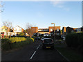
2
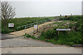
New ramp up to Telscombe Tye
Presumably replacing steps, and enabling wheelchair access to the Tye, a large area of common land.
Image: © Robin Webster
Taken: 19 May 2010
0.04 miles
3
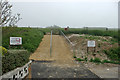
New ramp up to Telscombe Tye, 2010
Presumably replacing steps, and enabling wheelchair access to the Tye, a large area of common land.
Image: © Robin Webster
Taken: 19 May 2010
0.04 miles
4
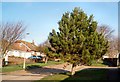
Fir Tree in Banning Vale
Taken on Christmas Day 2009
Image: © Paul Gillett
Taken: 25 Dec 2009
0.04 miles
5
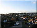
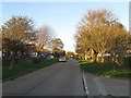
Bevendean Avenue, Saltdean
One of the original roads laid out in the 1920s that runs between Ashurst Avenue in the east to Shepham Avenue in the west. This view looks towards the crossroads with Bannings Vale. The section beyond up to the junction with Cissbury Avenue was not developed until the 1960s.
Image: © Simon Carey
Taken: 27 Oct 2012
0.05 miles
6
Chailey Crescent, Saltdean
Small crescent that runs off the eastern side of Bannings Vale that was built in the 1970s.
Image: © Simon Carey
Taken: 27 Oct 2012
0.06 miles
7
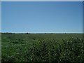
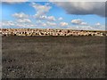
Telscombe Tye
View from Bevendean Avenue
Image: © Paul Gillett
Taken: 30 May 2009
0.06 miles
9

Greenacre, Northwood Avenue, Saltdean
Private Green area in the middle of the avenue, the road like several in the area remains unmade
Image: © Paul Gillett
Taken: 25 Dec 2012
0.09 miles
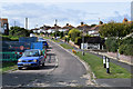
10
Bannings Vale, Saltdean
The main arterial road for eastern Saltdean that runs along the length of what was Bannings Bottom. The road was laid out in the 1920s and was lined with trees thougha fair number failed to survive due to the then exposed nature of the terrain.
Image: © Simon Carey
Taken: 27 Oct 2012
0.10 miles