IMAGES TAKEN NEAR TO
The Vale, BRIGHTON, BN2 7AB
Introduction
This page details the photographs taken nearby to The Vale, BN2 7AB by members of the Geograph project.
The Geograph project started in 2005 with the aim of publishing, organising and preserving representative images for every square kilometre of Great Britain, Ireland and the Isle of Man.

There are currently over 7.5m images from over14,400 individuals and you can help contribute to the project by visiting https://www.geograph.org.uk
Image Map
Images are licensed for reuse under creativecommons.org/licenses/by-sa/2.0
Notes
- Clicking on the map will re-center to the selected point.
- The higher the marker number, the further away the image location is from the centre of the postcode.
Image Listing (21 Images Found)
Images are licensed for reuse under creativecommons.org/licenses/by-sa/2.0
Image
Details
Distance
1
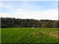
The Eighteen Acres
The name of the field according to Ovingdean's 1839 tithe map that lies between Falmer Road to the east, The Vale to the west and south, and Ovingdean Road to the north. About half of the field is used for pasture and the other as a playing field belonging to Image
Image: © Simon Carey
Taken: 28 Dec 2015
0.07 miles
2
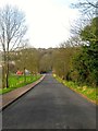
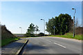
Ovingdean Road, Ovingdean
Heading down the eastern side of Long Hill. The steepness of the road can be seen by the provision of a handrail along the pavement to the right.
Image: © Simon Carey
Taken: 28 Dec 2015
0.12 miles
3

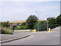
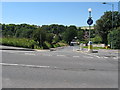
Ovingdean Road
Viewed from the junction with Falmer Road, the B2123, the eastern entrance to the village of Ovingdean. The road itself heads down into the dip then climbs up and over Long Hill to get to the centre of the settlement.
Image: © Simon Carey
Taken: 28 Dec 2015
0.12 miles
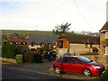
4
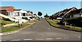
The Vale, Ovingdean
A public highway up to the entrance of Image after which the road turns north becoming a private track up to Ovingdean Road. The latter part was developed towards the end of the 1930s.
Image: © Simon Carey
Taken: 28 Dec 2015
0.13 miles
5
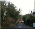
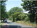
Hill crest, Ovingdean Road
A steep rise up to this point.
Image: © Robin Webster
Taken: 2 Mar 2010
0.13 miles
6
Ovingdean Road Ovingdean
Small village to the west of Rottingdean.
Image: © Dave Spicer
Taken: 22 Jul 2012
0.14 miles
8
Entrance Path to Longhill School
Longhill High School is a specialist technology college, see the schools website: http://www.longhill.brighton-hove.sch.uk/
Image: © Paul Gillett
Taken: 23 Jun 2009
0.14 miles
9
Meadow Vale, Ovingdean Road, Ovingdean
Once the outbuildings of Woodingdean Farm which were converted around 1985-86. The houses beyond are Image
Image: © Simon Carey
Taken: 28 Dec 2015
0.15 miles