IMAGES TAKEN NEAR TO
Camberlot Road, HAILSHAM, BN27 3RG
Introduction
This page details the photographs taken nearby to Camberlot Road, BN27 3RG by members of the Geograph project.
The Geograph project started in 2005 with the aim of publishing, organising and preserving representative images for every square kilometre of Great Britain, Ireland and the Isle of Man.

There are currently over 7.5m images from over14,400 individuals and you can help contribute to the project by visiting https://www.geograph.org.uk
Image Map
Images are licensed for reuse under creativecommons.org/licenses/by-sa/2.0
Notes
- Clicking on the map will re-center to the selected point.
- The higher the marker number, the further away the image location is from the centre of the postcode.
Image Listing (52 Images Found)
Images are licensed for reuse under creativecommons.org/licenses/by-sa/2.0
Image
Details
Distance
3
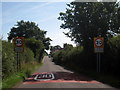
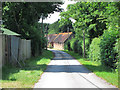
Camberlot Road
Minor road linking Upper Dicker to the A22. Its straight route is due to it being an enclosure road planned with a ruler by those responsible for enclosing Dicker Common in 1813. The houses on the left are Crossways Cottages built in the first decade of the 20th century to a design made by Sir Horatio Bottomley, who resided in nearby Crossway House and effectively acted as squire to the small village between 1889 when he arrived and 1929 when he departed after his fourth bankruptcy. The drive to Clifton Farm, Bottomley's horse racing stables until 1922, are to the left.
Image: © Simon Carey
Taken: 1 Jun 2011
0.15 miles
4
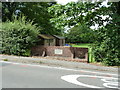
Coronation plaque on brick wall by Upper Dicker playing field
The inscription is 'King George VI Queen Elizabeth crowned May 12th 1937.
Image: © Dave Spicer
Taken: 5 Aug 2012
0.18 miles
5
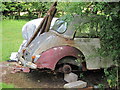
Abandoned Morris Minor
Derelict 1960's Morris Minor in a field beside the track to Clifton Farm.
Image: © Oast House Archive
Taken: 7 Jun 2011
0.19 miles
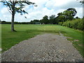
7
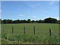
Six Acres
The name of the field according to Arlington's 1843 tithe map that lies immediately to the west of Clifton Farm.
Image: © Simon Carey
Taken: 1 Jun 2011
0.19 miles
8
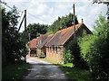
Stable block at Clifton Farm
Luxury stables at Clifton Farm, a former stud farm.
Image: © Oast House Archive
Taken: 7 Jun 2011
0.19 miles
9
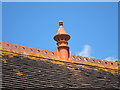
Chimney at Clifton Farm stables
What appears to be an ornate chimney in a former stable block at Clifton Farm. Seen in Image
Image: © Oast House Archive
Taken: 7 Jun 2011
0.19 miles
10
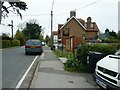
Upper Dicker village sign
The Weald Way long distance path turns right by the village notice board.
Image: © Dave Spicer
Taken: 7 May 2012
0.20 miles