IMAGES TAKEN NEAR TO
Wheel Gardens, HAILSHAM, BN27 2FL
Introduction
This page details the photographs taken nearby to Wheel Gardens, BN27 2FL by members of the Geograph project.
The Geograph project started in 2005 with the aim of publishing, organising and preserving representative images for every square kilometre of Great Britain, Ireland and the Isle of Man.

There are currently over 7.5m images from over14,400 individuals and you can help contribute to the project by visiting https://www.geograph.org.uk
Image Map
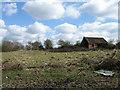
Images are licensed for reuse under creativecommons.org/licenses/by-sa/2.0
Notes
- Clicking on the map will re-center to the selected point.
- The higher the marker number, the further away the image location is from the centre of the postcode.
Image Listing (29 Images Found)
Images are licensed for reuse under creativecommons.org/licenses/by-sa/2.0
Image
Details
Distance
1
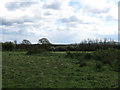
Horse Pasture
The name of the field according to the 1844 tithe map. The South Downs are just visible on the horizon to the right.
Image: © Simon Carey
Taken: 3 May 2010
0.02 miles
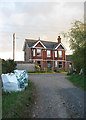
2
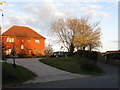
House on Mill Road
A new house on the corner of Mill Road next to the entrance to Lion House caravan park catches the late evening sun.
Image: © Simon Carey
Taken: 3 May 2010
0.05 miles
3
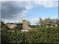
Remains of a Barn, Mill Farm
Derelict and overgrown.
Image: © Simon Carey
Taken: 3 May 2010
0.05 miles
4

Four Acres
The name of the field according to the 1844 tithe map.
Image: © Simon Carey
Taken: 15 Apr 2010
0.07 miles
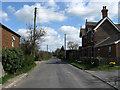
5

Mill Road
Taken from a junction of lanes to the east of Hailsham. White Dyke Road heads off to the right whilst Mill Road heads towards Hailsham eventually becoming Market Street.
Image: © Simon Carey
Taken: 15 Apr 2010
0.07 miles
6
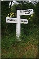
Old Direction Sign - Signpost by Mill Road, Hailsham Parish
Black iron cap finial - 3 arms; East Sussex wood by the UC road, in parish of Hailsham (Wealden District), Mill Road junction with Old Swan Lane. (Once a road across Pevensey Levels, now disused except as a farm access), on grass verge.
Surveyed
Milestone Society National ID: SX_TQ6008
Image: © Milestone Society
Taken: Unknown
0.09 miles
7
Rickyard Meadow
The name of the field according to the 1844 tithe map. The dilapidated building on the far side was once part of Mill Farm.
Image: © Simon Carey
Taken: 11 Apr 2010
0.09 miles
8
Hamlins Villa
Victorian house on Mill Road next to the site of the old windmill from which it got its name. Viewed from the track to Little Marshfoot Farm which is also a public footpath.
Image: © Simon Carey
Taken: 3 May 2010
0.11 miles
9

Old Swan Lane
Heading south from the junction with White Dyke Road towards Station Road. The footpath on the right heads towards Hailsham.
Image: © Simon Carey
Taken: 15 Apr 2010
0.11 miles
10
Mill Road
The road heads south east out of Hailsham towards White Dyke. The building on the right is Hamlins Villa.
Image: © Simon Carey
Taken: 11 Apr 2010
0.12 miles