IMAGES TAKEN NEAR TO
Butlers Lane, HAILSHAM, BN27 1QH
Introduction
This page details the photographs taken nearby to Butlers Lane, BN27 1QH by members of the Geograph project.
The Geograph project started in 2005 with the aim of publishing, organising and preserving representative images for every square kilometre of Great Britain, Ireland and the Isle of Man.

There are currently over 7.5m images from over14,400 individuals and you can help contribute to the project by visiting https://www.geograph.org.uk
Image Map
Images are licensed for reuse under creativecommons.org/licenses/by-sa/2.0
Notes
- Clicking on the map will re-center to the selected point.
- The higher the marker number, the further away the image location is from the centre of the postcode.
Image Listing (18 Images Found)
Images are licensed for reuse under creativecommons.org/licenses/by-sa/2.0
Image
Details
Distance
1
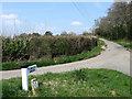
Butlers Lane
Single track lane that links Lower Road at Golden Cross to Flowers Green. The top end of the triangle at the junction is just in this square whilst the water main marker gives an idea of the size of the signpost.
Image: © Simon Carey
Taken: 15 Apr 2010
0.08 miles
2
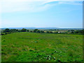
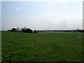
Where Weald meets Levels
Looking down the edge of the Weald towards Pevensey Levels with the South Downs on the horizons. The farm on the extreme right is Sackville Farm.
Image: © Simon Carey
Taken: 27 Jul 2008
0.09 miles
3
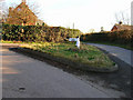
Old Direction Sign - Signpost by Lower Road, Golden Cross
Black iron cap finial - 1 arm; East Sussex wood by the UC road, in parish of Herstmonceux (Wealden District), Lower Road, on grass triangle at junction of Butlers Lane with Lower Road.
Surveyed
Milestone Society National ID: SX_TQ6310
Image: © Milestone Society
Taken: Unknown
0.11 miles
4
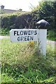
Signpost for little people, Golden Cross.
On the junction of Lower Road and Butlers Lane at Golden Cross. This view looks east.
Image: © Simon Carey
Taken: 21 Jan 2006
0.12 miles
5
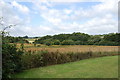
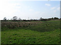
Bridge Field
The name of the field according to the 1839 tithe map that lies next to Iron Stream.
Image: © Simon Carey
Taken: 15 Apr 2010
0.15 miles
8
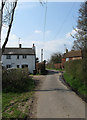
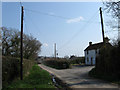
Golden Cross
The name of the small hamlet that can be found at the junction of Lower Road and Butlers Lane. Here the former heads towards the latter passing Ivy Cottage on the left and Yew Tree Cottage to the right.
Image: © Simon Carey
Taken: 15 Apr 2010
0.16 miles
9
Second Piece
The name of the field according to the 1839 tithe map. Viewed from the footpath that links Lower Road to New Bridge Road.
Image: © Simon Carey
Taken: 15 Apr 2010
0.18 miles
10
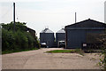
Chantler's Farmhouse
On Lower Road with the farm buildings out of shot to the right. The chimney and roof beyond belongs to Sackville Farmhouse whose farm the small lorry on the left is heading for.
Image: © Simon Carey
Taken: 15 Apr 2010
0.19 miles