IMAGES TAKEN NEAR TO
Litlington Road, SEAFORD, BN25 4AH
Introduction
This page details the photographs taken nearby to Litlington Road, BN25 4AH by members of the Geograph project.
The Geograph project started in 2005 with the aim of publishing, organising and preserving representative images for every square kilometre of Great Britain, Ireland and the Isle of Man.

There are currently over 7.5m images from over14,400 individuals and you can help contribute to the project by visiting https://www.geograph.org.uk
Image Map
Images are licensed for reuse under creativecommons.org/licenses/by-sa/2.0
Notes
- Clicking on the map will re-center to the selected point.
- The higher the marker number, the further away the image location is from the centre of the postcode.
Image Listing (61 Images Found)
Images are licensed for reuse under creativecommons.org/licenses/by-sa/2.0
Image
Details
Distance
1
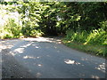
Sharp bend on the Litlington Road
By Knowle Cottage.
Image: © Dave Spicer
Taken: 25 Jul 2012
0.04 miles
2
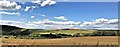
View WNW across Cuckmere River valley from the Vanguard Way
Image: © Ian Hawfinch
Taken: 10 Jul 2020
0.06 miles
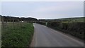
3
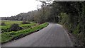
Litlington Road - Minor Rural Road near litlington
Image: © James Emmans
Taken: 22 Apr 2016
0.07 miles
4

Clue Brook
The name of the field according to Lullington's 1845 tithe map viewed from Litlington Road. A strip of land to the south of the village of Litlington was a detached portion of Lullington parish. This view looks up the Cuckmere Valley about twenty minutes before sunset. To the north is Image
Image: © Simon Carey
Taken: 17 Oct 2013
0.08 miles
5
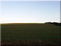
Nineteen Acres (1)
The name of the field according to Westdean's 1840 tithe map viewed from Litlington Road. This is the northern part of the field that has been subdivided into two sections, the southern lies to the south of the hedge on the right.
Image: © Simon Carey
Taken: 17 Oct 2013
0.08 miles
6
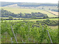
Towards Charleston Bottom
View over the vines -Chardonnay - from the Rathfinny Trail towards Charleston Bottom and the fringes of Friston Forest.
Image: © David M Clark
Taken: 28 Aug 2022
0.09 miles
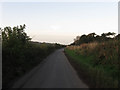
7
Litlington Road - Minor Rural Road near Charleston Manor
Image: © James Emmans
Taken: 22 Apr 2016
0.09 miles
8
Litlington Road
The name of the lane that runs down the eastern side of the Cuckmere valley linking litlington with the A259 at Exceat. Beyond the hedge to the left is Image whilst to the right is Image
Image: © Simon Carey
Taken: 17 Oct 2013
0.10 miles
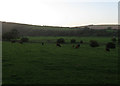
9
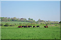
Cows near Litlington Road
Just beyond are the banks of the Cuckmere River.
Image: © Oast House Archive
Taken: 22 Apr 2011
0.10 miles
10
Little Hor
The name of the field according to Lullington's 1845 tithe map. I think there may be a transcription error here as the adjacent field to the south is Image and whoever was reading the original manuscript has somehow mistaken an 'e' for an 'r'. However, without seeing the original apportionment I am currently unable to confirm this supposition. The bushes beyond the cows mark the boundary between this detached portion of Lullington and Alfriston beyond and is possibly an old course of the Cuckmere River which sometime in the past has shifted a little to the north. On the far side of the valley is the northern slope of High and Over.
Image: © Simon Carey
Taken: 17 Oct 2013
0.10 miles