IMAGES TAKEN NEAR TO
Alfriston Road, SEAFORD, BN25 3AB
Introduction
This page details the photographs taken nearby to Alfriston Road, BN25 3AB by members of the Geograph project.
The Geograph project started in 2005 with the aim of publishing, organising and preserving representative images for every square kilometre of Great Britain, Ireland and the Isle of Man.

There are currently over 7.5m images from over14,400 individuals and you can help contribute to the project by visiting https://www.geograph.org.uk
Image Map
Images are licensed for reuse under creativecommons.org/licenses/by-sa/2.0
Notes
- Clicking on the map will re-center to the selected point.
- The higher the marker number, the further away the image location is from the centre of the postcode.
Image Listing (83 Images Found)
Images are licensed for reuse under creativecommons.org/licenses/by-sa/2.0
Image
Details
Distance
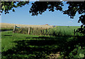
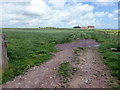
1
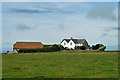
Farm near High and Over
On Alfriston Road.
Image: © Robin Webster
Taken: 13 Aug 2011
0.02 miles
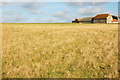
2
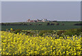
Farm Buildings at High & Over, Seaford, East Sussex
The view was taken from Dymocks Farm, Seaford.
Image: © Kevin Gordon
Taken: 8 May 2008
0.03 miles
3
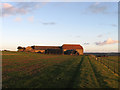
Barn, High and Over
The rear view of the flint barn that lies next to Alfriston Road on High and Over. All the land in a triangle bounded by the road and two bridleways is open access.
Image: © Simon Carey
Taken: 1 Jan 2013
0.03 miles
4
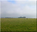
High and Over, Cradle Hill
Taken from the bridleway heading south and looking east along Cradle Hill to its peak at High and Over on the left of the picture. The southern edge of the grid square enters roughly where the sheep are standing on the right hand side and goes to the left of the barn.
Image: © Simon Carey
Taken: 14 Feb 2006
0.04 miles
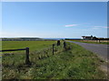
5
Farm Buildings on Alfriston Road, Seaford.
The road is known locally as the White Way probably as it was cut through the underlying chalk.
Image: © Kevin Gordon
Taken: 22 Jul 2008
0.04 miles
6
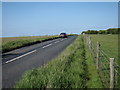
Alfriston Road
Road between Seaford and Alfriston.
Image: © Oast House Archive
Taken: 19 May 2011
0.04 miles
7
Farm buildings, Alfriston Road, just North of Seaford
Image: © Mike Alexander
Taken: Unknown
0.05 miles
8
Trig point by Alfriston Road
Heading for Seaford.
Image: © Dave Spicer
Taken: 13 Sep 2012
0.05 miles
10
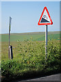
Incline sign, Alfriston Road
10% slope sign on road between Seaford and Alfriston.
Image: © Oast House Archive
Taken: 19 May 2011
0.08 miles