IMAGES TAKEN NEAR TO
Surrey Close, SEAFORD, BN25 2NL
Introduction
This page details the photographs taken nearby to Surrey Close, BN25 2NL by members of the Geograph project.
The Geograph project started in 2005 with the aim of publishing, organising and preserving representative images for every square kilometre of Great Britain, Ireland and the Isle of Man.

There are currently over 7.5m images from over14,400 individuals and you can help contribute to the project by visiting https://www.geograph.org.uk
Image Map
Images are licensed for reuse under creativecommons.org/licenses/by-sa/2.0
Notes
- Clicking on the map will re-center to the selected point.
- The higher the marker number, the further away the image location is from the centre of the postcode.
Image Listing (79 Images Found)
Images are licensed for reuse under creativecommons.org/licenses/by-sa/2.0
Image
Details
Distance
1
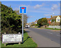
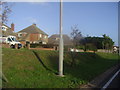
Surrey Road, Seaford
Named after the Surrey Convalescent Home which once stood on this site.
Image: © Kevin Gordon
Taken: 3 Mar 2008
0.04 miles
2
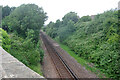
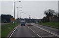
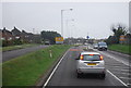
Seaford branch line west of Claremont Road
A single track line opened in 1864, from 1904 until 1975 it was double track.
Image: © Robin Webster
Taken: 15 Jul 2010
0.04 miles
3
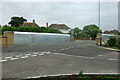
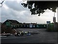
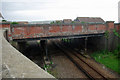
Railway bridge STS/811, Seaford
This has recently (2010) been rebuilt with a slab concrete span and is equipped with more robust parapets composed of galvanized steel framing clad with sheeting. Previously with a 7.5 ton weight limit, it is unclear whether this still applies, as at the far end the sign has been reversed, and at this end the sign is directed sideways along the railway - both invisible to approaching traffic. Later the weight restriction signs were properly removed.
Image: © Robin Webster
Taken: 15 Jul 2010
0.09 miles
4
Railway bridge STS/811, Seaford
This has recently been rebuilt with a slab concrete span and is equipped with more robust parapets composed of galvanized steel framing clad with sheeting. Previously with a 7.5 ton weight limit, it is unclear whether this still applies, as at the far end the sign has been reversed, and at this end the sign is directed sideways along the railway - both invisible to approaching traffic. Later the weight restriction signs were properly removed.
Image: © Robin Webster
Taken: 15 Jul 2010
0.09 miles
7
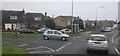
Lambes Bridge
Now a recycling centre and small car park for a nearby parade of shops but formerly the northern end of Edinburgh Road at its junction with Claremont Road. The former has been diverted to join the latter to the south of the railway.
Image: © Simon Carey
Taken: 15 Nov 2009
0.11 miles
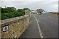
10
Railway bridge STS/812, Seaford
Viewed from bridge STS/811. The bridge has been disused as a road bridge for some years, and more recently had a domestic recycling station partly on it. This has now closed, as from 11/12/2009. The bridge now bears some raw earth and paving, which might become flowerbeds or lawn. It still acts as a pedestrian bridge, slightly more convenient in some directions than using bridge STS/811.
Image: © Robin Webster
Taken: 15 Jul 2010
0.11 miles