IMAGES TAKEN NEAR TO
Bevendean Road, BRIGHTON, BN2 4DU
Introduction
This page details the photographs taken nearby to Bevendean Road, BN2 4DU by members of the Geograph project.
The Geograph project started in 2005 with the aim of publishing, organising and preserving representative images for every square kilometre of Great Britain, Ireland and the Isle of Man.

There are currently over 7.5m images from over14,400 individuals and you can help contribute to the project by visiting https://www.geograph.org.uk
Image Map
Images are licensed for reuse under creativecommons.org/licenses/by-sa/2.0
Notes
- Clicking on the map will re-center to the selected point.
- The higher the marker number, the further away the image location is from the centre of the postcode.
Image Listing (34 Images Found)
Images are licensed for reuse under creativecommons.org/licenses/by-sa/2.0
Image
Details
Distance
1
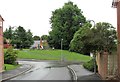
Recreation area, Fitzherbert Drive
An open area with facilities for children on a modern housing estate
Image: © Patrick Roper
Taken: 25 Aug 2010
0.02 miles
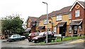
2
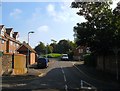
Fitzherbert Drive, Brighton
Built in the mid 1990s on southern end of the site once occupied by Bevendean Hospital. Viewed from the junction with Bevendean Road.
Image: © Simon Carey
Taken: 11 Oct 2015
0.05 miles
3

House in Tenantry Road, Brighton
House at the junction of Tenantry Road and Fitzherbert Drive. The name 'Tenantry' comes from Tenantry Down and the area is in one of the former tenanted land divisions of Brighton known as 'laines'. 'Laine' was the local term for open arable fields common in medieval agriculture before enclosure.
Image: © Patrick Roper
Taken: 25 Aug 2010
0.05 miles
4
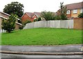
Amenity grass bank, Fitzherbert Drive
Some green open space on a modern (c. 2005) housing estate.
Image: © Patrick Roper
Taken: 25 Aug 2010
0.06 miles
5
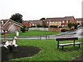
Playpark by Fitzherbert Drive
A children's play area in the Meadowview part of Brighton. Fitzherbert Drive is named after Mrs Fitzherbert who secretly married George IV when he was still Prince of Wales. She lived in Brighton for much of her life and is buried in Kemp Town.
Image: © Patrick Roper
Taken: 25 Aug 2010
0.07 miles
6
Borrow King Close, Brighton
Built around 2005, this short cul-de-sac is named after Arthur Borrow King (1924-1992), a Brighton councillor.
Image: © Patrick Roper
Taken: 25 Aug 2010
0.09 miles


9
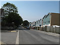
New housing on Bevendean Road
Looking at old Google images it appears that some of the houses in Baden Road, which back onto these new builds, have sold about half of their back gardens to accommodate.
Image: © Dave Spicer
Taken: 12 Aug 2012
0.10 miles
10

Gates of former Bevendean Hospital, Brighton
Built in the late 19th century, Bevendean Hospital was closed in 1990 and then replaced by housing. These gates and gate piers on the south east side of Bevendean Road were retained and are Grade II Listed Buildings
Image: © Patrick Roper
Taken: 25 Aug 2010
0.10 miles