IMAGES TAKEN NEAR TO
Lewes Road, BRIGHTON, BN2 3JZ
Introduction
This page details the photographs taken nearby to Lewes Road, BN2 3JZ by members of the Geograph project.
The Geograph project started in 2005 with the aim of publishing, organising and preserving representative images for every square kilometre of Great Britain, Ireland and the Isle of Man.

There are currently over 7.5m images from over14,400 individuals and you can help contribute to the project by visiting https://www.geograph.org.uk
Image Map
Images are licensed for reuse under creativecommons.org/licenses/by-sa/2.0
Notes
- Clicking on the map will re-center to the selected point.
- The higher the marker number, the further away the image location is from the centre of the postcode.
Image Listing (227 Images Found)
Images are licensed for reuse under creativecommons.org/licenses/by-sa/2.0
Image
Details
Distance
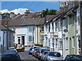
1
Round Hill Crescent
Road off of Upper Lewes Road, it does what it says on the tin (or rather the roadsign!)
Image: © Paul Gillett
Taken: 20 Jul 2010
0.01 miles
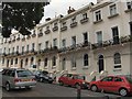
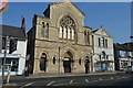
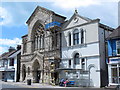
2
Stanley Court, Lewes Road
Built in 1878 as a Congregational Chapel it has now been converted into 31 flats and is run by Brighton YMCA.
Image: © Simon Carey
Taken: 12 Mar 2013
0.02 miles
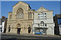
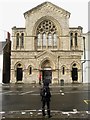
5
Stanley Court, Lewes Road, BN2
Part of Brighton YMCA's supported housing - see http://www.brightonymca.co.uk/stanley.html .
Image: © Mike Quinn
Taken: 25 Jun 2014
0.02 miles
7
Upper Lewes Road
Once the A27 and the major east-west route across Brighton until the construction of the by-pass in the early 1990s. Much of the area was developed in the 1860s and 70s. This is the view from its junction with the Vogue Gyratory.
Image: © Simon Carey
Taken: 25 Dec 2008
0.02 miles
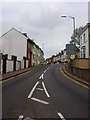
8

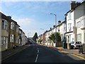
Inverness Road, Brighton
A small side street linking Lewes Road and Upper Lewes Road that was developed in the late 1860s.
Image: © Simon Carey
Taken: 25 Oct 2015
0.03 miles
9
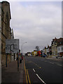
Lewes Road
Formerly the A27 it has been the A270 since the construction of the Brighton by-pass in the early 1990s. This is the approach to the traffic system known as the Vogue Gyratory which links Lewes Road and Upper Lewes Road with two other minor but busy routes, Hollingdean Road and Bear Road. It is one of the most confusing road junctions in Brighton. Until 1976 the view would also have taken in Lewes Road viaduct which carried the Kemp Town branch over this road between 1869-1971 when the line was closed. The orange building on the right marks the spot where it crossed.
Image: © Simon Carey
Taken: 25 Dec 2008
0.03 miles
10
Upper Lewes Road, Brighton
The A270 that runs between the Vogue Gyratory and Ditchling Road. Much of the road was developed in the early 1870s and for nearly all the 20th century was the A27 until 1991 when the Brighton Bypass was constructed.
Image: © Simon Carey
Taken: 11 Oct 2015
0.03 miles