IMAGES TAKEN NEAR TO
Edmund Close, EASTBOURNE, BN23 6TX
Introduction
This page details the photographs taken nearby to Edmund Close, BN23 6TX by members of the Geograph project.
The Geograph project started in 2005 with the aim of publishing, organising and preserving representative images for every square kilometre of Great Britain, Ireland and the Isle of Man.

There are currently over 7.5m images from over14,400 individuals and you can help contribute to the project by visiting https://www.geograph.org.uk
Image Map
Images are licensed for reuse under creativecommons.org/licenses/by-sa/2.0
Notes
- Clicking on the map will re-center to the selected point.
- The higher the marker number, the further away the image location is from the centre of the postcode.
Image Listing (54 Images Found)
Images are licensed for reuse under creativecommons.org/licenses/by-sa/2.0
Image
Details
Distance
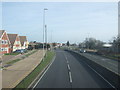
1
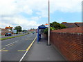
Bus stop 'Langney Green' Pevensey Road Eastbourne
Image: © PAUL FARMER
Taken: 28 Jul 2012
0.04 miles
2
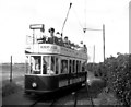
The Eastbourne tramway
The site of this photograph has now completely disappeared from view, being entirely built over. It shows the small pleasure tramway which used to operate on The Crumbles, a windswept shingle shore on the eastern fringes of Eastbourne. Open top car No 7 operated on a 2ft. gauge track.
Image: © Dr Neil Clifton
Taken: 21 Jun 1959
0.10 miles
3
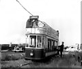
The Eastbourne tramway
The western extremity of this line was referred to as 'Princes Park', it being only about half a mile away from that place. Here is open-top car No 6.
Image: © Dr Neil Clifton
Taken: 21 Jun 1959
0.11 miles
4
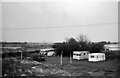
Near Pevensey ? 1966
The view was taken, from a passing bus, to include the old bus, which has remained unidentified (except that it is a Dennis chassis).
The main interest in the view is that it shows this section of the coast before the enormous Sovereign Harbour development arrived. The Martello Tower visible in the distance is No.65 at TQ 6470 0217.
Image: © Alan Murray-Rust
Taken: 11 Sep 1966
0.13 miles
5
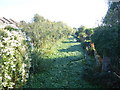
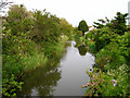
Langney Sewer
This looks eastwards from Langley Rise (B2104) at Langney Bridge. As with the 'sewers' on Romney Marsh, a sewer here is another name for a drainage ditch rather than a receptable for sewage. See http://www.geograph.org.uk/photo/5950105 for the view in the opposite direction across West Langney Level.
Image: © Marathon
Taken: 21 Oct 2018
0.13 miles
7
Christ the King Catholic Church, Eastbourne
Image: © PAUL FARMER
Taken: 28 Jul 2012
0.14 miles
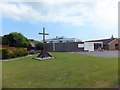
8
Christ the King Catholic Church, Princes Road
Construction of the Church was finished in 1967 and the adjacent hall was completed in January 1995.
Image: © Peter Holmes
Taken: 23 Apr 2013
0.14 miles
9
Langney Sewer, Langney
Taken from Langney Bridge. The stream is surrounded by housing estates.
Image: © Simon Carey
Taken: 28 May 2006
0.15 miles
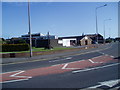
10

Liberal Democrats banner, Langney Rise
Image: © Oast House Archive
Taken: 24 Apr 2015
0.15 miles