IMAGES TAKEN NEAR TO
Devonshire Place, BRIGHTON, BN2 1QB
Introduction
This page details the photographs taken nearby to Devonshire Place, BN2 1QB by members of the Geograph project.
The Geograph project started in 2005 with the aim of publishing, organising and preserving representative images for every square kilometre of Great Britain, Ireland and the Isle of Man.

There are currently over 7.5m images from over14,400 individuals and you can help contribute to the project by visiting https://www.geograph.org.uk
Image Map
Images are licensed for reuse under creativecommons.org/licenses/by-sa/2.0
Notes
- Clicking on the map will re-center to the selected point.
- The higher the marker number, the further away the image location is from the centre of the postcode.
Image Listing (934 Images Found)
Images are licensed for reuse under creativecommons.org/licenses/by-sa/2.0
Image
Details
Distance
1
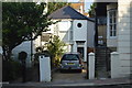
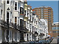
Devonshire Place, Brighton
A residential street running from St James's Street to Edward Street that was developed in the 1820s parts by well known architects Busby and Wilds. Tyson Place is the high rise in the distance.
Image: © Simon Carey
Taken: 11 Oct 2015
0.02 miles
2
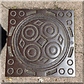
Coal plate, St. James's Avenue, Brighton
An unlettered plate set in a square frame. Although not alone in this area, I can't recall noticing a square frame anywhere else.
Image: © Robin Webster
Taken: 19 Jul 2016
0.03 miles
3
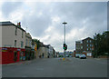
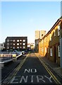
Edward Street
Head south down Tillstone Street then west along Eastern Road until the crossroads with Upper Rock Gardens and Egremont Place is reached. The eastern end of Edward Street and prime example of how street widening has left original buildings on one side of the road and replaced it with the modern on the other side.
Click on the link to take you to the next page. http://www.geograph.org.uk/photo/232064
Image: © Simon Carey
Taken: 1 Sep 2006
0.03 miles
4
National Spiritualist Church, Edward Street
head north along Devonshire Place then west along Edward Street. The church is between Blaker and Grosvenor Streets and was constructed in 1964-65 to replace another in Mighell Street. The design is a figure of eight and the lack of windows on the street side give it a strange, mysterious feeling.
Click on the link to take you to the next page. http://www.geograph.org.uk/photo/231676
Image: © Simon Carey
Taken: 1 Sep 2006
0.03 miles
5
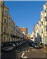
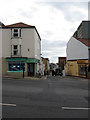
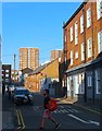
Chapel Street, Brighton
A residential road linking St James's Street with Edward Street that was originally developed in the 1800s but nothing now remains from that era. Much of the original housing was removed in the 1930s with the rest going in the 1960s. Small terraces have been rebuilt on the eastern side whilst much of the west is taken up with the high rise St James's Lodge. Tyson Place is the high rise block in the distance.
Image: © Simon Carey
Taken: 1 Nov 2015
0.03 miles
6
Chapel Street
Linking Edward Street to St James's Street. many of the small terraced houses were demolished in the 1960s to make way for the High Street development whose high rise flats are visible to the right.
Image: © Simon Carey
Taken: 7 Oct 2011
0.04 miles
7
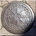
Coal plate, St. James's Avenue, Brighton
'T. W. Porter Star Foundry Brighton'. The foundry was on Bread Street, with an official address on Church Street. It closed in the 1900s. In 1890 the proprietor was A. Burstow. A plate with his name is shown in Image Whether Porter was in charge before or after Burstow has not yet been determined. I also have a suspicion ironmongers sometimes got the foundry to cast their own names on the plates, otherwise there were an awful lot of foundries about in some fairly small areas.
Image: © Robin Webster
Taken: 19 Jul 2016
0.04 miles
9
Chapel Street, Brighton
A residential road that runs between St James's Street and Edward Street that was first developed in the 1800s but has little of its original buildings remaining. On the eastern side in view the houses date from the mid 1990s, the previous ones demolished during the 1980s and then left as parking. All of the western side has been removed mainly in the 1960s to make way for St James's House another high rise block.
Image: © Simon Carey
Taken: 11 Oct 2015
0.04 miles