IMAGES TAKEN NEAR TO
Hampshire Court, Upper St. James's Street, BRIGHTON, BN2 1LN
Introduction
This page details the photographs taken nearby to Hampshire Court, Upper St. James's Street, BN2 1LN by members of the Geograph project.
The Geograph project started in 2005 with the aim of publishing, organising and preserving representative images for every square kilometre of Great Britain, Ireland and the Isle of Man.

There are currently over 7.5m images from over14,400 individuals and you can help contribute to the project by visiting https://www.geograph.org.uk
Image Map
Images are licensed for reuse under creativecommons.org/licenses/by-sa/2.0
Notes
- Clicking on the map will re-center to the selected point.
- The higher the marker number, the further away the image location is from the centre of the postcode.
Image Listing (688 Images Found)
Images are licensed for reuse under creativecommons.org/licenses/by-sa/2.0
Image
Details
Distance
1
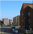
Veronica Way, Brighton
An access road for Hampshire Court that joins Essex Street to the north. Developed in the early 1970s.
Image: © Simon Carey
Taken: 11 Oct 2015
0.00 miles
2
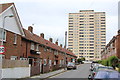
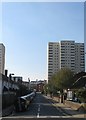
Lavender Street, Brighton
The road originally ran from Upper St James's Street to Eastern Road but since the 1960s now ends at the junction with Hereford Street. Originally developed in the 1810s the area soon became a notorious slum and began to be cleared in the late 1920s but was not completed until the 1960s. The former high density terraced housing was replaced with flats and five high rises, two of which, Wiltshire House and Hereford Court, are in view.
Image: © Simon Carey
Taken: 4 Oct 2015
0.02 miles
3
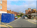
Hereford Street
Head south out of Park Street across Eastern Road then take a footpath to Hereford Street. Originally developed between 1809-21 this area was also cleared of slums between 1926-28 and rebuilt during the 1930s before being halted by the war then recommencing from the late 1950s as can be seen by the mixture of styles evident in this pcture.
This page is the last of the tour of TQ3104.
Image: © Simon Carey
Taken: 1 Sep 2006
0.03 miles
4
Essex Street, Brighton
The residential street was first developed in the 1810s and originally ran from Upper Bedford Street to Lavender Street. The northern side was cleared in the late 1950s and replaced by the blocks of flats. Those on the southern side up to an old school were removed in the 1930s but not replaced due to the war with the rest removed in the 1960s when the houses on the left were built. During the early 1970s the western end of the street was closed and Wiltshire House, the high rise block of flats, built.
See following images:
1. Northern side before development in 1954 - http://regencysociety-jamesgray.com/volume22/source/jg_22_182.html
2. Northern side after development in 1970 - http://regencysociety-jamesgray.com/volume22/source/jg_22_183.html
3. Southern side before development in 1967 - http://regencysociety-jamesgray.com/volume22/source/jg_22_181.html
Image: © Simon Carey
Taken: 11 Oct 2015
0.04 miles
5
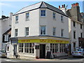
Kemp Cafe, Upper St. James's Street / Wyndham Street, BN2
Image: © Mike Quinn
Taken: 22 May 2012
0.05 miles
6
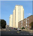
Essex Street
Wiltshire House tower block ahead.
Image: © Oast House Archive
Taken: 9 Jun 2013
0.05 miles
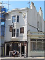
8
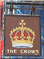
Sign for The Crown, Grafton Street, BN2
See Image
Image: © Mike Quinn
Taken: 22 May 2012
0.05 miles
9
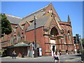
St Mary's Church, St James's Street
At the junction of Upper Rock Gardens. Taken from the junction with Lower Rock Gardens.
Image: © Robin Sones
Taken: 6 Jun 2010
0.05 miles
10
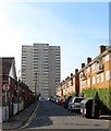
Hereford Street, Brighton
A residential street that runs from Upper Bedford Street to Lavender Street that was originally developed in the 1810s and soon became one of the worst slum areas of Brighton. Subsequently, these houses were one of the first to be cleared in the mid 1920s and replaced by a new set of council housing which were some of the worst ever built by the local authority. Consequently, they too were demolished by the Luftwaffe during the war and by the council soon after and replaced by yet another set which have consequently proved a little more durable though some of them were also been removed in the mid 1970s to be replaced by a block of flats . The high rise on the right is Hereford Court built in the late 1960s on the site of a former malthouse which by that point was being used to manufacturer gas mantles. Hereford Street's one claim to fame is it being the birthplace of Thomas Sargent in 1896 who later became the comedian Max Miller.
Old images:
The northern side in 1924 - http://regencysociety-jamesgray.com/volume22/source/jg_22_156.html
Bomb damage during the Second World War - http://regencysociety-jamesgray.com/volume22/source/jg_22_164.html
Replacement houses and old malthouse 1961 - http://regencysociety-jamesgray.com/volume22/source/jg_22_168.html
Image: © Simon Carey
Taken: 11 Oct 2015
0.06 miles