Hereford Street, Brighton
Introduction
The photograph on this page of Hereford Street, Brighton by Simon Carey as part of the Geograph project.
The Geograph project started in 2005 with the aim of publishing, organising and preserving representative images for every square kilometre of Great Britain, Ireland and the Isle of Man.

There are currently over 7.5m images from over 14,400 individuals and you can help contribute to the project by visiting https://www.geograph.org.uk
Hereford Street, Brighton
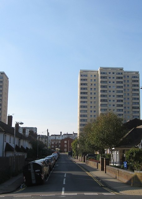
Image: © Simon Carey Taken: 11 Oct 2015
A residential street that runs from Upper Bedford Street to Lavender Street that was originally developed in the 1810s and soon became one of the worst slum areas of Brighton. Subsequently, these houses were one of the first to be cleared in the mid 1920s and replaced by a new set of council housing which were some of the worst ever built by the local authority. Consequently, they too were demolished by the Luftwaffe during the war and by the council soon after and replaced by yet another set which have consequently proved a little more durable though some of them were also been removed in the mid 1970s to be replaced by a block of flats . The high rise on the right is Hereford Court built in the late 1960s on the site of a former malthouse which by that point was being used to manufacturer gas mantles. Hereford Street's one claim to fame is it being the birthplace of Thomas Sargent in 1896 who later became the comedian Max Miller. Old images: The northern side in 1924 - http://regencysociety-jamesgray.com/volume22/source/jg_22_156.html Bomb damage during the Second World War - http://regencysociety-jamesgray.com/volume22/source/jg_22_164.html Replacement houses and old malthouse 1961 - http://regencysociety-jamesgray.com/volume22/source/jg_22_168.html
Images are licensed for reuse under creativecommons.org/licenses/by-sa/2.0
Image Location
Latitude
50.820865
Longitude
-0.127264