IMAGES TAKEN NEAR TO
John Street, BRIGHTON, BN2 0LA
Introduction
This page details the photographs taken nearby to John Street, BN2 0LA by members of the Geograph project.
The Geograph project started in 2005 with the aim of publishing, organising and preserving representative images for every square kilometre of Great Britain, Ireland and the Isle of Man.

There are currently over 7.5m images from over14,400 individuals and you can help contribute to the project by visiting https://www.geograph.org.uk
Image Map
Images are licensed for reuse under creativecommons.org/licenses/by-sa/2.0
Notes
- Clicking on the map will re-center to the selected point.
- The higher the marker number, the further away the image location is from the centre of the postcode.
Image Listing (879 Images Found)
Images are licensed for reuse under creativecommons.org/licenses/by-sa/2.0
Image
Details
Distance
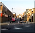
1
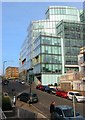
1 John Street, Brighton
The new offices of American Express whose exterior was completed in 2012. The move from neighbouring Image began soon after and I believe was completed this summer.
Image: © Simon Carey
Taken: 4 Oct 2015
0.02 miles
3
Police Station, John Street, Brighton
Image: © Oast House Archive
Taken: 25 Jul 2008
0.02 miles
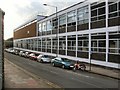
4
Police Station, John Street
Head north along John Street and behind the law courts is the city's police headquarters. Also designed by Percy Billington and opened in 1965 it was long a concrete eyesore but some recladding and colouring seems to have soften its appearance compared to the harsh concrete of the law courts. Built over a previous area of slums.
Click on the link to take you to the next page. http://www.geograph.org.uk/photo/231490
Image: © Simon Carey
Taken: 1 Sep 2006
0.04 miles
5
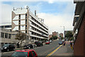
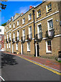
William Street, Brighton
The road runs between Edward street and Kingswood Street and was originally developed in 1815 though nothing remains from that period. The eastern side was cleared in the mid 1930s and is now occupied by either the Law Courts or Police Station. The western side had to wait until the 1960s before that was cleared and has been replaced by the County Court on the immediate left and buildings belonging to the University of Brighton further on.
Image: © Simon Carey
Taken: 1 Nov 2015
0.04 miles
6
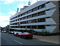
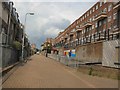
Nelson Row
Head north along John Street to the junction with Carlton Hill head south a little until the junction with Nelson Row. The original Nelson Row along the Nelson Place and Woburn were some of the most deprived areas in Brighton during the early part of the 20th century and were some of the earliest to be cleared. Milner Flats to the left and Kingswood Flats to the right were constructed by the corporation in 1934 and 1938 respectively.
Click on the link to take you to the next page. http://www.geograph.org.uk/photo/231502
Image: © Simon Carey
Taken: 1 Sep 2006
0.04 miles
7
34-35 Mighell Street
Head south down Tilbury Place and at the junction with Carlton Hill is also one with Mighell Street. Hidden away behind a garage is the only house in the street, an old early 19th century farmhouse. The street survived the slum clearances of the 1960s but the southern end was demolished in the mid 1970s for an office development. The parking space is used by the probation service though the house itself seems to be hidden behind windowboards.
Click on the link to take you to the next page. http://www.geograph.org.uk/photo/231650
Image: © Simon Carey
Taken: 1 Sep 2006
0.05 miles
8
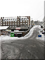
Kingswood Street
Continues further up as Carlton Hill and is another contender for steepest hill in Brighton. The police, whose main station is round the corner in John Street, have decided to close a section between there and Circus Street which heads out to the left.. Kingswood Flats are to the left further up.
Image: © Simon Carey
Taken: 2 Feb 2009
0.05 miles
9
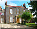
Tilbury Place
Head south down John Street then east up Carlton Hill and north into Tilbury Place.Number 1 was developed as St Johns Lodge in 1810 and the rest of the row followed in 1812 and initially called Patriot Place but renamed Tilbury in 1862 after Edwin Tarner's wife's maiden name. The northern end is closed off by Prior House constructed in 1936 and just visible and the western side provides the entrance to Carlton Hill Primary School. The row was given to Brighton Corporation in 1933 and number 1 became known as Tarner House.
Click on the link to take you to the next page. http://www.geograph.org.uk/photo/231643
Image: © Simon Carey
Taken: 1 Sep 2006
0.05 miles
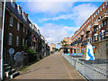
10
Nelson Row, Brighton
Flats built in 1930's
Image: © Paul Gillett
Taken: 11 Jun 2011
0.05 miles