1
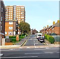
Grosvenor Street, Brighton
A cul de sac off Edward Street that was redeveloped in the 1960s having originally linked Edward Street to Carlton Hill. Tyson Place is the block of flats at the end of the street and the BYC on the building to the right stands for Brighton Youth club.
Image: © Simon Carey
Taken: 4 Oct 2015
0.01 miles
2
Grosvenor Street
Viewed from the junction with Edward Street with Tyson Place, the large block of flats at the end of the truncated street. The street was largely demolished in the late 1950s in tandem with the widening of Edward Street at the beginning of the following decade. On the left is part of the National Spiritualist Church built as a figure of eight in 1964 whilst to the right is Brighton Youth Centre originally founded as the Brighton Boys club in 1917 down the road in John Street. This new building was opened in 1957.
Image: © Simon Carey
Taken: 7 Oct 2011
0.02 miles
3
Mount Pleasant
Head south down Marine View then east along Carlton Hill. Mount Pleasant was first developed from 1800 but failed to live up to its name by becoming a notorious slum which was eventually demolished in 1935. It was rebuilt and widened to include another alley, Park Place and the eastern side was completed before the outbreak of the second world war. The war then the shortages in the aftermath meant the western side was not built until the 1960s. A theme often running in this part of the city, odd buildings and wasteland surviving from the 1930s but not fully redeveloped until the money reappeared in the 1960s.
Click on the link to take you to the next page. http://www.geograph.org.uk/photo/232047
Image: © Simon Carey
Taken: 1 Sep 2006
0.03 miles
4
Blaker Street, Brighton
A residential road that runs between Edward Street and Carlton Hill that was developed in the late 1890s after the previous slums in Chesterfield street and Derby Place, which dated from the 1810s, were cleared.
Image: © Simon Carey
Taken: 4 Oct 2015
0.03 miles
5
Brighton: Blaker Street
Image: © Christopher Hilton
Taken: 26 Mar 2019
0.03 miles
6
Blaker Street, Brighton
Perhaps overdoing the reaction against white & cream painted hotels.
Image was more tasteful.
Image: © Keith Edkins
Taken: 22 Sep 2012
0.04 miles
7
Small Factory, Marine View
Head east down Sussex Street the south down Queens Park Road then west along Park Road Terrace. A survivor of the slum clearances in this area which had started in the 1930s but only completed in the 1960s. The houses to the right are the only other survivors.
Click on the link to take you to the next page. http://www.geograph.org.uk/photo/232043
Image: © Simon Carey
Taken: 1 Sep 2006
0.04 miles
8
52, Carlton Hill, Brighton
Located on the corner of Marine View is the former Devonshire public house which closed around 2008, the last of the pubs in Carlton Hill which once numbered fifteen. The original pub dates from the 1840s but was rebuilt during the 1930s.
Image: © Simon Carey
Taken: 1 Nov 2015
0.04 miles
9
Mount Pleasant, Brighton
The road was originally laid out in the 1800s but was anything but pleasant as the area north of Edward Street and west of egremont Place soon became a slum area. The eastern side was cleared and rebuilt in the 1930s but the western side had to wait until the 1960s. St John's Mount is the block of flats on the left.
Image: © Simon Carey
Taken: 4 Oct 2015
0.04 miles
10
Brighton Spiritualist Church
A fair amount of money must have been spirited up for this remarkable windowless building on a prominent site. Its local rival, the Brighton and Hove Spiritualist Church, is a far humbler establishment in far humbler surroundings.
Image: © Robin Webster
Taken: 19 Jul 2016
0.05 miles


