IMAGES TAKEN NEAR TO
Tilgate Close, BRIGHTON, BN2 0FL
Introduction
This page details the photographs taken nearby to Tilgate Close, BN2 0FL by members of the Geograph project.
The Geograph project started in 2005 with the aim of publishing, organising and preserving representative images for every square kilometre of Great Britain, Ireland and the Isle of Man.

There are currently over 7.5m images from over14,400 individuals and you can help contribute to the project by visiting https://www.geograph.org.uk
Image Map
Images are licensed for reuse under creativecommons.org/licenses/by-sa/2.0
Notes
- Clicking on the map will re-center to the selected point.
- The higher the marker number, the further away the image location is from the centre of the postcode.
Image Listing (55 Images Found)
Images are licensed for reuse under creativecommons.org/licenses/by-sa/2.0
Image
Details
Distance
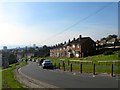
1
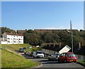
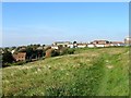
Tillgate Close, Brighton
A cul de sac off Queensway that is part of the Craven Vale estate built in 1953. The houses beyond are in The Causeway that was developed in the early 1990s with the Whitehawk Hill transmitter to the right.
Image: © Simon Carey
Taken: 11 Oct 2015
0.01 miles
2
Flats in Queensway
At the top end of Craven Vale
Image: © Paul Gillett
Taken: 20 Jul 2014
0.03 miles
3
Craven Road
In the Craven Vale housing estate
Image: © Paul Gillett
Taken: 20 Jul 2014
0.03 miles
4
Craven Road, Brighton
A road that starts and finishes off Queensway that is part of the Craven Vale estate that was built in 1953 in what was Bakers Bottom. The Whitehawk Hill television transmitter is on the right above the trees.
Image: © Simon Carey
Taken: 11 Oct 2015
0.04 miles
5
Queensway, Brighton
The road runs northwards as a continuation of Sutherland Road and ends at Fredshfield Road next to the racecourse. It was laid out around 1953 as the main arterial route through a new council estate built in Bakers Bottom that was given the name Craven Vale. This view looks south west towards the sea and distant i360 under construction.
Image: © Simon Carey
Taken: 11 Oct 2015
0.06 miles
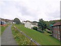
6
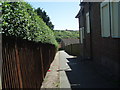
Craven Path
Between Freshfield Road and Sutherland Road with Whitehawk Hill in the background
Image: © Paul Gillett
Taken: 17 May 2009
0.06 miles
7
Monument View
Small housing estate built sometime in the 1990s next to the pulling up area of Brighton Racecourse.
Image: © Simon Carey
Taken: 29 Aug 2011
0.08 miles
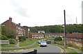
8
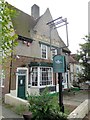
Freshfield Inn
In Freshfield Road near the racecourse http://www.viewbrighton.co.uk/pubsandbars/freshfield-inn-info-26063.html
Image: © Paul Gillett
Taken: 20 Jul 2014
0.08 miles
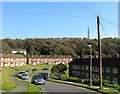
9
Whitehawk Camp
Whitehawk Hill contains the earliest recorded inhabited site in Brighton being the location of a form Neolithic camp that has been dated back to 2700BC, older than Stonehenge. Some of ditches which form concentric circles that cross both Manor Hill and the racecourse can still be seen. In this view they are located by the uneven ground to the left. Beyond are the houses in The Causeway with the stables belonging to Brighton Racecourse straight ahead.
Image: © Simon Carey
Taken: 11 Oct 2015
0.10 miles
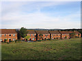
10
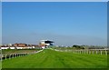
Pulling Up Area, Brighton Racecourse
Added in 1952 and located to the south of Manor Hill which is closed on race days and turfed over. The course starts on the northern side of Red Hill and runs in a horseshoe shape around Whitehawk Bottom which contains the suburb of Whitehawk, crossing Wilson Avenue, which is also closed on race days and turfed over, before heading towards the grandstand where the finishing post is located. To the left of the stand are the stables.
Image: © Simon Carey
Taken: 11 Oct 2015
0.11 miles